Posts

Showing posts from July, 2019

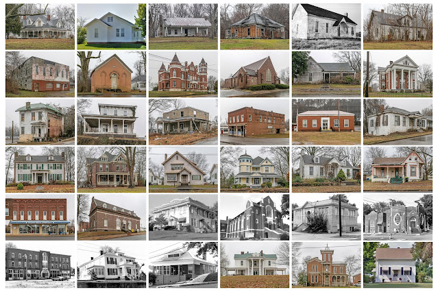
Ballard County, Kentucky

Image
Founding:  1842 Parent counties:  Hickman and McCracken Namesake:  Bland Ballard, Kentucky politician Seat:  Blandville (1842–1882); Wickliffe (1882–) Land area:  247 square miles Population (2020):  7,728 Population (historic):  5,496 (1850); 12,576 (1870); 8,390 (1890); 12,690 (1910); 9,910 (1930) Periods of population growth:  pre-1850–1910; 1970s; 1990s Subdivisions:  Five cities; two CDPs National Register listings:   Six Pre-1940 residences (estimated):  250 (6.4%) Pre-1940 housing survival rate:  16.1% Pre-1860 housing survival rate (1940):  5.1% Farm housing in disrepair (1950):  14.6% Nonfarm housing in disrepair (1950):  15.7% Average farmhouse value (1930):  $505 Average outbuilding value (1930):  $356 Average farmhouse size (1940):  4.4 rooms Number of farms (1920):  1,979 Average farm size (1920):  55.1 acres _________________________________________________________________________________ Wickliffe Namesake:  Charles Wickliffe, Kentucky g

Graves County, Kentucky

Image
Founding:  1824 Parent county:  Hickman Namesake:  Benjamin Graves, Michigan supreme court justice Seat:  Mayfield (1824–) Land area:  552 square miles Population (2020):  36,649 Population (historic):  2,504 (1830); 16,233 (1860); 24,138 (1880); 33,204 (1900); 30,778 (1930) Periods of population growth:  pre-1830–1910; 1930s; 1960–1980; 1990–2010 Subdivisions:  Three cities; seven CDPs National Register listings:   11 Pre-1940 residences (estimated):  1,161 (6.9%) Pre-1940 housing survival rate:  22.6% Pre-1860 housing survival rate (1940):  2.4% Farm housing in disrepair (1950):  19.8% Nonfarm housing in disrepair (1950):  12.4% Average farmhouse value (1930):  $437 Average outbuilding value (1930):  $260 Average farmhouse size (1940):  4 rooms Number of farms (1920):  6,082 Average farm size (1920):  42.7 acres _________________________________________________________________________________ Mayfield Namesake:  Mayfield Creek Founding:  1823 (post

Daviess County, Kentucky

Image
Founding:  1815 Parent county:  Ohio Namesake:  Joseph Daveiss, Indiana militia commander Seat:  Owensboro (1816–) Land area:  458 square miles Population (2020):  103,312 Population (historic):  3,876 (1820); 12,362 (1850); 20,714 (1870); 38,667 (1900); 43,779 (1930) Periods of population growth:  pre-1820–1910; 1920–2020 Subdivisions:  Two cities; three CDPs National Register listings:   39 Pre-1940 residences (estimated):  2,912 (6.8%) Pre-1940 housing survival rate:  28.2% Pre-1860 housing survival rate (1940):  13.4% Farm housing in disrepair (1950):  16% Nonfarm housing in disrepair (1950):  14.1% Average farmhouse value (1930):  $726 Average outbuilding value (1930):  $604 Average farmhouse size (1940):  4.6 rooms Number of farms (1920):  3,808 Average farm size (1920):  53 acres _________________________________________________________________________________ Owensboro Namesake:  Abraham Owen, Kentucky soldier Founding:  1816 (platting as Owe

Marshall County, Kentucky

Image
Founding:  1842 Parent county:  Calloway Namesake:  John Marshall, Supreme Court chief justice Seat:  Benton (1842–) Land area:  301 square miles Population (2020):  31,659 Population (historic):  5,269 (1850); 9,455 (1870); 11,287 (1890); 15,771 (1910); 12,889 (1930) Periods of population growth:  pre-1850–1910; 1930s; 1950–2020 Subdivisions:  Three cities; one CDP National Register listings:   Six Pre-1940 residences (estimated):  526 (3.3%) Pre-1940 housing survival rate:  17.4% Pre-1860 housing survival rate (1940):  2.3% Farm housing in disrepair (1950): 12.9% Nonfarm housing in disrepair (1950): 10% Average farmhouse value (1930):  $398 Average outbuilding value (1930):  $203 Average farmhouse size (1940):  3.7 rooms Number of farms (1920):  3,353 Average farm size (1920):  39 acres _________________________________________________________________________________ Benton Namesake:  Thomas Benton, Missouri politician Founding:  1842 (platting); 1

Calloway County, Kentucky

Image
Founding:  1822 Parent county:  Hickman Namesake:  Richard Calloway, Kentucky settler Seat:   Wadesboro (1822–1842); Murray (1842–) Land area:  385 square miles Population (2020):  37,103 Population (historic):  5,164 (1830); 9,915 (1860); 13,295 (1880); 17,633 (1900); 17,662 (1930) Periods of population growth:  pre-1830–1840; 1850s; 1870–1920; 1930–2010 Subdivisions:  Two cities; one CDP National Register listings:   17 Pre-1940 residences (estimated):  970 (5.2%) Pre-1940 housing survival rate:  22.6% Pre-1860 housing survival rate (1940):  2.4% Farm housing in disrepair (1950): 14.3% Nonfarm housing in disrepair (1950): 12.7% Average farmhouse value (1930):  $453 Average outbuilding value (1930):  $247 Average farmhouse size (1940):  4.1 rooms Number of farms (1920):  4,293 Average farm size (1920):  38 acres _________________________________________________________________________________ Murray Namesake:  John Murray, Kentucky politician Foundi

Fulton County, Kentucky

Image
Founding:  1845 Parent county:  Hickman Namesake:  Robert Fulton, inventor of the steamboat Seat:  Hickman (1845–) Land area:  206 square miles Population (2020):  6,515 Population (historic):  4,446 (1850); 6,161 (1870); 10,005 (1890); 14,114 (1910); 14,927 (1930) Periods of population growth:  pre-1850–1920; 1930s Subdivisions:  Two cities; one CDP National Register listings:   16 Pre-1940 residences (estimated):  354 (10.5%) Pre-1940 housing survival rate:  18.1% Pre-1860 housing survival rate (1940):  3% Farm housing in disrepair (1950):  23.8% Nonfarm housing in disrepair (1950):  19.5% Average farmhouse value (1930):  $735 Average outbuilding value (1930):  $387 Average farmhouse size (1940):  4.3 rooms Number of farms (1920):  1,205 Average farm size (1920):  69.5 acres _________________________________________________________________________________ Hickman Namesake:  Uncertain—perhaps Paschal Hickman, Kentucky soldier Founding:  circa 1820 (

Laurel County, Kentucky

Image
Founding:  1825 Parent counties:  Clay, Knox, Rockcastle, and Whitley Namesake:  The Laurel River Seat:  London (1825–) Land area:  434 square miles Population (2020):  62,613 Population (historic):  2,206 (1830); 5,488 (1860); 9,131 (1880); 17,592 (1900); 21,109 (1930) Periods of population growth:  pre-1830–1910; 1920–1950; 1960–2020 Subdivisions:  One city; two CDPs National Register listings:   Nine Pre-1940 residences (estimated):  1,050 (4.1%) Pre-1940 housing survival rate:  16.9% Pre-1860 housing survival rate (1940):  4.9% Farm housing in disrepair (1950): 20.1% Nonfarm housing in disrepair (1950): 22.2% Average farmhouse size (1940):  4.3 rooms Average farmhouse value (1930):  $402 Average outbuilding value (1930):  $173 Number of farms (1920):  2,937 Average farm size (1920):  35.2 acres _________________________________________________________________________________ London Namesake:  London, England Founding:  1825 (platting); 1831 (post

Letcher County, Kentucky

Image
Founding:  1842 Parent counties:  Perry and Harlan Namesake:  Robert Letcher, Kentucky governor Seat:  Whitesburg (1842–) Land area:  338 square miles Population (2020):  21,548 Population (historic):  2,512 (1850); 4,608 (1870); 6,920 (1890); 10,623 (1910); 35,702 (1930) Periods of population growth:  pre-1850–1940; 1970s Subdivisions:  Four cities; four CDPs National Register listings:   Five Pre-1940 residences (estimated):  1,566 (13.4%) Pre-1940 housing survival rate:  21.5% Pre-1860 housing survival rate (1940):  6% Farm housing in disrepair (1950): 23% Nonfarm housing in disrepair (1950): 20% Average farmhouse value (1930):  $342 Average outbuilding value (1930):  $133 Average farmhouse size (1940):  3.6 rooms Number of farms (1920):  1,601 Average farm size (1920):  31.8 acres _________________________________________________________________________________ Whitesburg Namesake:  Daugherty White, Kentucky politician Founding:  1842 (platting);

Pike County, Kentucky

Image
Founding:  1821 Parent county:  Floyd Namesake:  Zebulon Pike, American explorer Seat:  Pikeville (1824–) Land area:  787 square miles Population (2020):  58,669 Population (historic):  2,677 (1830); 7,384 (1860); 13,001 (1880); 22,686 (1900); 63,267 (1930) Periods of population growth:  pre-1830–1950; 1970s Subdivisions:  Three cities; five CDPs National Register listings:   16 Pre-1940 residences (estimated):  1,683 (5.5%) Pre-1940 housing survival rate:  15.6% Pre-1860 housing survival rate (1940):  3.8% Farm housing in disrepair (1950): 24.2% Nonfarm housing in disrepair (1950): 20.3% Average farmhouse value (1930):  $473 Average outbuilding value (1930):  $168 Average farmhouse size (1940):  3.9 rooms Number of farms (1920):  4,471 Average farm size (1920):  29.8 acres _________________________________________________________________________________ Pikeville Namesake:  Zebulon Pike, American explorer Founding:  1824 (platting); 1825 (post offic

Hopkins County, Kentucky

Image
Founding:  1806 Parent county:  Henderson Namesake:  Samuel Hopkins, Kentucky politician Seat:  Madisonville (1808–) Land area:  542 square miles Population (2020):  45,423 Population (historic):  2,964 (1810); 9,171 (1840); 13,827 (1870); 30,995 (1900); 37,449 (1930) Periods of population growth:  pre-1810–1850; 1860–1910; 1920–1950; 1970s Subdivisions:  Nine cities; one CDP National Register listings:   33 Pre-1940 residences (estimated):  2,507 (11.7%) Pre-1940 housing survival rate:  26% Pre-1860 housing survival rate (1940):  8.7% Farm housing in disrepair (1950): 16.3% Nonfarm housing in disrepair (1950): 16.1% Average farmhouse value (1930):  $600 Average outbuilding value (1930):  $327 Average farmhouse size (1940):  3.9 rooms Number of farms (1920):  3,473 Average farm size (1920):  55.3 acres _________________________________________________________________________________ Madisonville Namesake:  James Madison, U.S. president Founding:  180

Hickman County, Kentucky

Image
Founding:  1821 Parent county:  Unorganized territory Namesake:  Paschal Hickman, Kentucky soldier Seat:  Columbus (1821–1830); Clinton (1830–) Land area:  242 square miles Population (2020):  4,521 Population (historic):  5,198 (1830); 7,008 (1860); 10,651 (1880); 11,745 (1900); 8,725 (1930) Periods of population growth:  pre-1830–1840; 1850–1900; 1930s Subdivisions:  Two cities National Register listings:   Five Pre-1940 residences (estimated):  281 (11.9%) Pre-1940 housing survival rate:  17.4% Pre-1860 housing survival rate (1940):  2% Farm housing in disrepair (1950):  27.2% Nonfarm housing in disrepair (1950):  29.8% Average farmhouse value (1930):  $523 Average outbuilding value (1930):  $376 Average farmhouse size (1940):  4.4 rooms Number of farms (1920):  1,649 Average farm size (1920):  69.3 acres _________________________________________________________________________________ Clinton Namesake:  Unknown Founding:  1828 (platting); 1829 (p

Floyd County, Kentucky

Image
Founding:  1799 Parent counties:  Fleming, Mason, and Montgomery Namesake:  James Floyd, Kentucky militia colonel Seat:  Prestonsburg (1800–) Land area:  393 square miles Population (2020):  35,942 Population (historic):  3,485 (1810); 6,302 (1840); 7,877 (1870); 15,552 (1900); 41,942 (1930) Periods of population growth:  pre-1810–1820; 1830s; 1850–1950; 1970s Subdivisions:  Five cities; five CDPs National Register listings:   16 Pre-1940 residences (estimated):  1,576 (8.6%) Pre-1940 housing survival rate:  15.3% Pre-1860 housing survival rate (1940):  3.8% Farm housing in disrepair (1950): 27.8% Nonfarm housing in disrepair (1950): 23.4% Average farmhouse value (1930):  $444 Average outbuilding value (1930):  $190 Average farmhouse size (1940):  3.9 rooms Number of farms (1920):  3,032 Average farm size (1920):  29 acres _________________________________________________________________________________ Prestonsburg Namesake:  John Preston, owner of th

Webster County, Kentucky

Image
Founding:  1860 Parent counties:  Henderson, Hopkins, and Union Namesake:  Daniel Webster, New Hampshire politician Seat:  Dixon (1860–) Land area:  332 square miles Population (2020):  13,017 Population (historic):  10,937 (1870); 17,196 (1890); 20,974 (1910); 20,532 (1930) Periods of population growth:  pre-1870–1910; 1970s; 1990s Subdivisions:  Six cities; two CDPs National Register listings:   Three Pre-1940 residences (estimated):  821 (13.8%) Pre-1940 housing survival rate:  23.9% Pre-1860 housing survival rate (1940):  3.4% Farm housing in disrepair (1950): 11.7% Nonfarm housing in disrepair (1950): 18.3% Average farmhouse value (1930):  $529 Average outbuilding value (1930):  $347 Average farmhouse size (1940):  4.1 rooms Number of farms (1920):  2,407 Average farm size (1920):  55.4 acres _________________________________________________________________________________ Dixon Namesake:  Archibald Dixon, Kentucky politician Founding:  1860 (pl

Oscoda County, Michigan

Image
Founding:  1881 (declared in 1840) Parent county:  Unorganized territory Namesake:  A neologism coined by Henry Schoolcraft Seat:   Union Corners (1881–1888); Mio (1888–) Land area:  566 square miles Population (2020):  8,219 Population (historic):  467 (1880); 1,468 (1900); 1,728 (1930) Periods of population growth:  1870–1890; 1900s; 1930–2000 Subdivisions:  One CDP; six townships National Register listings:   One Pre-1940 residences (estimated):  432 (4.7%) Farm housing in disrepair (1950):  8.5% Nonfarm housing in disrepair (1950):  3.9% Average farmhouse value (1930):  $884 Average outbuilding value (1930):  $949 Average farmhouse size (1940):  5.9 rooms Number of farms (1920):  278 Average farm size (1920):  56.4 acres Sources of settlement:  Michigan, Ohio, and Canada _________________________________________________________________________________ Mio Namesake:  A nickname for Marla DeYarmond, wife of the village's founder Founding:  1881

Ohio County, Kentucky

Image
Founding:  1798 Parent county:  Hardin Namesake:  The Ohio River Seat:  Hartford (1798–) Land area:  587 square miles Population (2020):  23,772 Population (historic):  1,223 (1800); 6,592 (1840); 15,561 (1870); 27,287 (1900); 24,469 (1930) Periods of population growth:  pre-1800–1910; 1960–1980; 1990–2010 Subdivisions:  Six cities; one CDP National Register listings:   19 Pre-1940 residences (estimated):  813 (7.9%) Pre-1940 housing survival rate:  20.5% Pre-1860 housing survival rate (1940):  15.2% Farm housing in disrepair (1950): 22.4% Nonfarm housing in disrepair (1950): 18.5% Average farmhouse value (1930):  $487 Average outbuilding value (1930):  $273 Average farmhouse size (1940):  4.1 rooms Number of farms (1920):  4,112 Average farm size (1920):  53.2 acres _________________________________________________________________________________ Hartford Namesake:  Fort Hartford, which once existed near the city site Founding:  1798 (platting); 180

Grayson County, Kentucky

Image
Founding:  1810 Parent counties:  Hardin and Ohio Namesake:  William Grayson, Virginia politician Seat:  Leitchfield (1810–) Land area:  497 square miles Population (2020):  26,420 Population (historic):  4,055 (1820); 6,837 (1850); 11,580 (1870); 19,878 (1900); 17,055 (1930) Periods of population growth:  pre-1820; 1830–1910; 1930s; 1960–2020 Subdivisions:  Three cities; one CDP National Register listings:   11 Pre-1940 residences (estimated):  827 (6.1%) Pre-1940 housing survival rate:  21.3% Pre-1860 housing survival rate (1940):  9% Farm housing in disrepair (1950): 25% Nonfarm housing in disrepair (1950): 19.1% Average farmhouse value (1930):  $316 Average outbuilding value (1930):  $215 Average farmhouse size (1940):  3.9 rooms Number of farms (1920):  3,362 Average farm size (1920):  59.1 acres _________________________________________________________________________________ Leitchfield Namesake:  David Leitch, owner of the city site Founding: