Posts

Showing posts from November, 2019

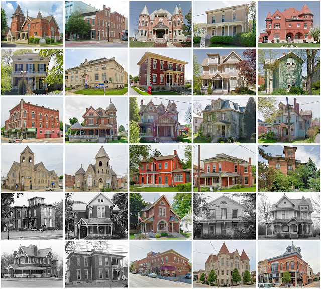
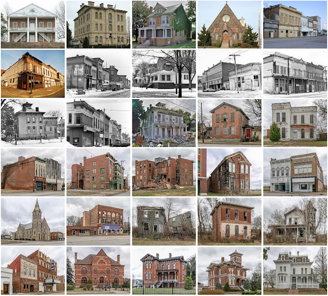
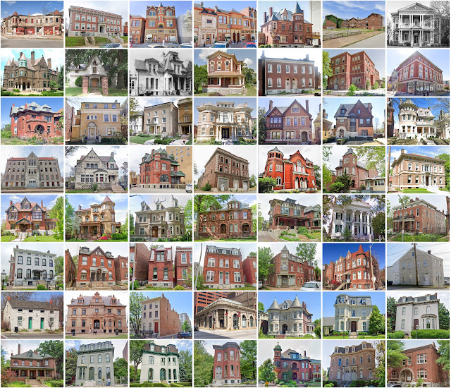
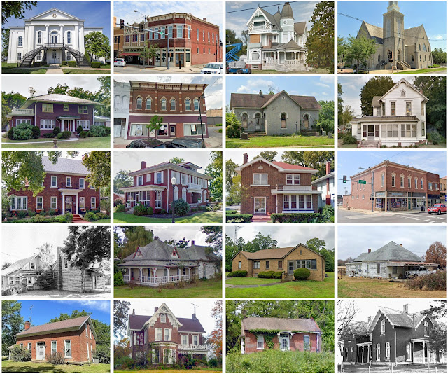
Rock Island County, Illinois

Image
Founding:  1833 (declared in 1831) Parent county:  Jo Daviess Namesake:  Rock Island Seat:  Rock Island (1835–) Land area:  428 square miles Population (2020):  144,672 Population (historic):  2,610 (1840); 21,005 (1860); 38,302 (1880); 55,249 (1900); 98,191 (1930) Periods of population growth:  pre-1840–1970; 1990s Subdivisions:  Four cities; 11 villages; two CDPs; 18 townships National Register listings:   32 Pre-1940 residences (estimated):  16,895 (25.6%) Pre-1940 housing survival rate:  51.8% Pre-1860 housing survival rate (1940):  16.4% Farm housing in disrepair (1950):  7.9% Nonfarm housing in disrepair (1950):  4.3% Average farmhouse value (1930):  $2,428 Average outbuilding value (1930):  $2,171 Average farmhouse size (1940):  6.3 rooms Number of farms (1920):  2,045 Average farm size (1920):  87.3 acres Sources of settlement:  Germany, Pennsylvania, New York, Ohio, and Sweden _________________________________________________________________________

Cass County, Indiana

Image
Founding:  1828 Parent county:  Unorganized territory Namesake:  Lewis Cass, Michigan politician Seat:  Logansport (1829–) Land area:  412 square miles Population (2010):  38,966 Population (historic):  1,162 (1830); 11,021 (1850); 24,193 (1870); 34,545 (1900); 34,518 (1930) Periods of population growth:  1830–1900 Subdivisions:  One city; seven towns; 14 townships National Register listings:   17 Pre-1940 residences (estimated):  6,900 (42.1%) Pre-1940 housing survival rate:  62.8% Pre-1860 housing survival rate (1940):  9.2% Average farmhouse value (1930):  $1,411 Average outbuilding value (1930):  $1,319 Average farmhouse size (1940):  6.6 rooms Number of farms (1920):  2,395 Average farm size (1920):  86.7 acres Sources of settlement:  Ohio, Pennsylvania, and Germany _________________________________________________________________________________ Logansport Namesake:  Unknown Founding:  1828 (platting); 1828 (post office) Population (2010):  18

Huntington County, Indiana

Image
Founding:  1834 (declared in 1832) Parent county:  Grant Namesake:  Samuel Huntington, third Ohio governor Seat:  Huntington (1834–) Land area:  383 square miles Population (2010):  37,124 Population (historic):  1,579 (1840); 14,867 (1860); 21,805 (1880); 28,901 (1900); 29,073 (1930) Periods of population growth:  pre-1840–1890; 1910s Subdivisions:  One city; five towns; 12 townships National Register listings:   20 Pre-1940 residences (estimated):  6,483 (40.5%) Pre-1940 housing survival rate:  69.1% Pre-1860 housing survival rate (1940):  9.3% Farm housing in disrepair (1950): 2.9% Nonfarm housing in disrepair (1950): 8.2% Average farmhouse value (1930):  $1,496 Average outbuilding value (1930):  $1,386 Average farmhouse size (1940):  6.9 rooms Number of farms (1920):  2,637 Average farm size (1920):  74.4 acres Sources of settlement:  Ohio, Pennsylvania, and Germany _________________________________________________________________________________ Hunti

Fulton County, New York

Image
Founding:  1838 Parent county:  Montgomery Namesake:  Robert Fulton, inventor of the steam engine Seat:  Johnstown (1838–) Land area:  495 square miles Population (2020):  53,324 Population (historic):  18,049 (1840); 24,162 (1860); 30,985 (1880); 42,842 (1900); 46,560 (1930) Periods of population growth:  pre-1840–1980; 1990–2010 Subdivisions:  Two cities; four villages; one CDP; ten towns National Register listings:   27 Pre-1940 residences (estimated):  10,423 (35.9%) Pre-1940 housing survival rate:  67% Pre-1860 housing survival rate (1940):  25.3% Farm housing in disrepair (1950):  12.5% Nonfarm housing in disrepair (1950):  7.5% Average farmhouse value (1930):  $1,847 Average outbuilding value (1930):  $1,544 Average farmhouse size (1940):  7.3 rooms Number of farms (1920):  1,773 Average farm size (1920):  50.1 acres _________________________________________________________________________________ Johnstown Namesake:  William Johnson, New York co

Putnam County, Illinois

Image
Founding:  1831 (declared in 1825) Parent county:  Unorganized territory Namesake:  Israel Putnam, Continental Army officer Seat:  Hennepin (1831–) Land area:  160 square miles Population (2020):  5,637 Population (historic):  2,131 (1840); 5,587 (1860); 5,554 (1880); 4,746 (1900); 5,235 (1930) Periods of population growth:  pre-1840–1870; 1890–1920; 1930s; 1960–1980; 1990s Subdivisions:  Six villages; four townships National Register listings:   Four Pre-1940 residences (estimated):  821 (26.3%) Pre-1940 housing survival rate:  52.5% Pre-1860 housing survival rate (1940):  17.4% Farm housing in disrepair (1950):  3.6% Nonfarm housing in disrepair (1950):  8% Average farmhouse value (1930):  $2,294 Average outbuilding value (1930):  $2,739 Average farmhouse size (1940):  6.9 rooms Number of farms (1920):  533 Average farm size (1920):  126.9 acres Sources of settlement:  Ohio, Pennsylvania, Germany, and New York ______________________________________________

Alexander County, Illinois

Image
Founding:  1819 Parent county:  Unorganized territory Namesake:  William Alexander, local physician Seat:   America (1819–1833); Unity (1833–1843); Thebes (1843–1860); Cairo (1860–) Land area:  236 square miles Population (2020):  5,240 Population (historic):  626 (1820); 2,484 (1850); 10,564 (1870); 19,384 (1900); 22,542 (1930) Periods of population growth:  pre-1820–1840; 1850–1920; 1930s; 1970s Subdivisions:  One city; four villages; one CDP; six precincts National Register listings:   Seven Pre-1940 residences (estimated):  1,310 (32.9%) Pre-1940 housing survival rate:  13% Pre-1860 housing survival rate (1940):  11.2% Farm housing in disrepair (1950):  17.3% Nonfarm housing in disrepair (1950):  20.5% Average farmhouse value (1930):  $718 Average outbuilding value (1930):  $640 Average farmhouse size (1940):  4 rooms Number of farms (1920):  731 Average farm size (1920):  85.3 acres Sources of settlement:  Tennessee, Kentucky, Missouri, and Ireland ____

St. Louis County, Missouri

Image
Founding:  1812 Parent county:  Unorganized territory Namesake:  The city of St. Louis Seat:  St. Louis (1812–1877); Clayton (1877–) Land area:  508 square miles Population (2020):  1,004,125 Population (historic):  10,049 (1820); 104,978 (1850); 351,189 (1870); 50,040 (1900); 211,593 (1930) Periods of population growth:  pre-1820–1870; 1880–1970 Subdivisions:  70 cities; 18 villages; ten CDPs;  National Register listings:   182 (and 435 in St. Louis proper) Pre-1940 residences (estimated):  42,830 (9.7%) Pre-1940 housing survival rate:  52.6% Pre-1860 housing survival rate (1940):  15.2% Farm housing in disrepair (1950):  5.8% Nonfarm housing in disrepair (1950):  9.5% Average farmhouse value (1930):  $2,767 Average outbuilding value (1930):  $1,778 Average farmhouse size (1940):  5 rooms Number of farms (1920):  3,735 Average farm size (1920):  47.5 acres ______________________________________________________________________________ St. Louis  (ex-seat)

St. Clair County, Illinois

Image
Founding:  1790 Parent county:  Unorganized territory Namesake:  Arthur St. Clair, governor of the Northwest Territory Seat:  Cahokia (1790–1814); Belleville (1814–) Land area:  658 square miles Population (2020):  257,400 Population (historic):  5,253 (1820); 20,180 (1850); 51,068 (1870); 86,685 (1900); 157,775 (1930) Periods of population growth:  pre-1820–1970; 2000s Subdivisions:  11 cities; 21 villages; five CDPs; 21 townships National Register listings:   31 Pre-1940 residences (estimated):  16,778 (14.1%) Pre-1940 housing survival rate:  33.7% Pre-1860 housing survival rate (1940):  31.2% Farm housing in disrepair (1950):  6.9% Nonfarm housing in disrepair (1950):  12.4% Average farmhouse value (1930):  $1,579 Average outbuilding value (1930):  $1,230 Average farmhouse size (1940):  5.3 rooms Number of farms (1920):  3,112 Average farm size (1920):  97.8 acres Sources of settlement:  Germany, Missouri, Ireland, England, France, Indiana, and Kentucky _

Jefferson County, Illinois

Image
Founding:  1819 Parent counties:  Edwards and White Namesake:  Thomas Jefferson, U.S. president Seat:  Mount Vernon (1819–) Land area:  571 square miles Population (2020):  37,113 Population (historic):  691 (1820); 8,109 (1850); 17,864 (1870); 28,133 (1900); 31,034 (1930) Periods of population growth:  pre-1820–1910; 1920–1950; 1970–2000 Subdivisions:  Two cities; seven villages; one CDP; 16 townships National Register listings:   Two Pre-1940 residences (estimated):  2,404 (14.2%) Pre-1940 housing survival rate:  29.7% Pre-1860 housing survival rate (1940):  5.2% Farm housing in disrepair (1950):  9.7% Nonfarm housing in disrepair (1950):  12% Average farmhouse value (1930):  $729 Average outbuilding value (1930):  $370 Average farmhouse size (1940):  4.7 rooms Number of farms (1920):  3,592 Average farm size (1920):  79.5 acres Sources of settlement:  Tennessee, Kentucky, Indiana, and Ohio __________________________________________________________________

Washington County, Illinois

Image
Founding:  1818 Parent county:  St. Clair Namesake:  George Washington, U.S. president Seat:  Covington (1818–1831); Nashville (1831–) Land area:  563 square miles Population (2020):  13,761 Population (historic):  1,517 (1820); 6,953 (1850); 17,599 (1870); 19,526 (1900); 16,286 (1930) Periods of population growth:  pre-1820–1880; 1890s; 1960–1980; 1990s Subdivisions:  Three cities; ten villages; 16 townships National Register listings:   Three Pre-1940 residences (estimated):  1,544 (23.3%) Pre-1940 housing survival rate:  40% Pre-1860 housing survival rate (1940):  7.7% Farm housing in disrepair (1950):  13.4% Nonfarm housing in disrepair (1950):  10.4% Average farmhouse value (1930):  $1,147 Average outbuilding value (1930):  $930 Average farmhouse size (1940):  5.2 rooms Number of farms (1920):  2,357 Average farm size (1920):  113.8 acres Sources of settlement:  Germany, Missouri, Tennessee, and Kentucky _________________________________________________

Racine County, Wisconsin

Image
Founding:  1836 Parent county:  Milwaukee Namesake:  The French word racine  ("root"), a reference to the Root River Seat:  Racine (1836–) Land area:  333 square miles Population (2020):  197,727 Population (historic):  3,475 (1840); 21,360 (1860); 30,922 (1880); 45,644 (1900); 90,217 (1930) Periods of population growth:  pre-1840–2020 Subdivisions:  Two cities; nine villages; five CDPs; six towns National Register listings:   57 Pre-1940 residences (estimated):  18,114 (22%) Pre-1940 housing survival rate:  63.2% Pre-1860 housing survival rate (1940):  22.1% Farm housing in disrepair (1950):  3.4% Average farmhouse value (1930):  $2,773 Average outbuilding value (1930):  $2,943 Average farmhouse size (1940):  6.8 rooms Number of farms (1920):  2,215 Average farm size (1920):  66.1 acres Sources of settlement:  Germany, New York, Denmark, Norway, England, and Ireland _______________________________________________________________________________