Posts

Showing posts from December, 2023

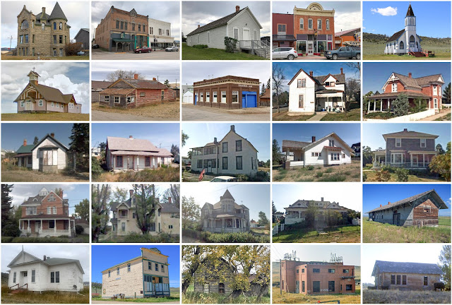
Throckmorton County, Texas

Image
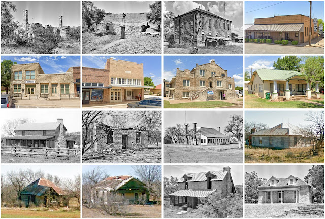
Founding:  1879 (declared in 1858) Parent county:  Unorganized territory Namesake:  William Throckmorton, early Texas settler Seat:  Throckmorton (1879–) Land area:  913 square miles Population (2020):  1,440 Population (historic):  124 (1860); 711 (1880); 1,750 (1900); 5,253 (1930) Periods of population growth:  pre-1860–1910; 1920s Subdivisions:  Two towns; one CDP National Register listings:   One Pre-1940 residences (estimated):  193 (20.9%) Pre-1940 housing survival rate:  28.8% Farm housing in disrepair (1950):  12.7% Nonfarm housing in disrepair (1950):  9.6% Average farmhouse value (1930):  $984 Average outbuilding value (1930):  $509 Average farmhouse size (1940):  4.2 rooms Number of farms (1920):  500 Average farm size (1920):  115.7 acres _________________________________________________________________________________   Throckmorton   Namesake:  Throckmorton County Founding:  1879 (platting); 1879 (post office); 1917 (incorporation) Population (2020):  727 Population (hist

Cannon County, Tennessee

Image
Founding:  1836 Parent counties:  Rutherford, Smith, Warren, and Wilson Namesake:  Newton Cannon, Tennessee governor Seat:  Woodbury (1836–) Land area:  266 square miles Population (2020):  14,506 Population (historic):  7,193 (1840); 9,509 (1860); 11,859 (1880); 12,121 (1900); 8,935 (1930) Periods of population growth:  pre-1840–1890; 1930s; 1970–2020 Subdivisions:  Two towns National Register listings:   10 Pre-1940 residences (estimated):  492 (7.8%) Pre-1940 housing survival rate:  22.2% Pre-1860 housing survival rate (1940):  10.1% Farm housing in disrepair (1950):  32.7% Nonfarm housing in disrepair (1950):  30.9% Average farmhouse value (1930):   $414 Average outbuilding value (1930):   $246 Average farmhouse size (1940):  3.7 rooms Number of farms (1920):  1,992 Average farm size (1920):  41.9 acres _________________________________________________________________________________   Woodbury   Namesake:  Levi Woodbury, New Hampshire politician Founding:  pre-1827 (founding as Da

Meagher County, Montana

Image
Founding:  1867 Parent counties:  Chouteau and Gallatin Namesake:  Thomas Meagher, Montana territorial governor Seat:   Diamond City (1867–1879); White Sulphur Springs (1879–) Land area:  2,392 square miles Population (2020):  1,927 Population (historic):  1,387 (1870); 4,749 (1890); 4,190 (1910); 2,272 (1930) Periods of population growth:  pre-1870–1890; 1900s; 1950s; 1970s; 1990s; 2010s Subdivisions:  One city; two CDPs National Register listings:   Six Pre-1940 residences (estimated):  382 (26.9%) Pre-1940 housing survival rate:  52.8% Farm housing in disrepair (1950):  4.1% Nonfarm housing in disrepair (1950):  5.7% Average farmhouse value (1930):  $1,011 Average outbuilding value (1930):  $1,695 Average farmhouse size (1940):  4.6 rooms Number of farms (1920):  447 Average farm size (1920):  306.1 acres _________________________________________________________________________________   White Sulphur Springs   Namesake:  Medicinal springs at the city site Founding:  1866 (founding

Chowan County, North Carolina

Image
Founding:  1671 Parent county:  Albemarle Namesake:  The Chowan River Seat:  Edenton (1715–) Land area:  173 square miles Population (2020):  13,708 Population (historic):  4,988 (1790); 6,690 (1840); 6,450 (1870); 10,258 (1900); 11,282 (1930) Periods of population growth:  pre-1790–1830; 1840–1860; 1870–1910; 1920–1950; 1970–2010 Subdivisions:  One town; three CDPs National Register listings:   25 Pre-1940 residences (estimated):  742 (10.4%) Pre-1940 housing survival rate:  34.7% Pre-1860 housing survival rate (1940):  25.7% Farm housing in disrepair (1950):  22.5% Nonfarm housing in disrepair (1950):  12.9% Average farmhouse value (1930):  $750 Average outbuilding value (1930):  $424 Average farmhouse size (1940):  5.3 rooms Number of farms (1920):  1,028 Average farm size (1920):  33 acres _________________________________________________________________________________   Edenton   Namesake:  Charles Eden, North Carolina governor Founding:  1712 (platting as Queen Anne's Town )

Pasquotank County, North Carolina

Image
Founding:  1684 Parent county:  Albemarle Namesake:  The Pasquotank River Seat:   Winfield (1765–1785); Nixonton (1785–1800); Elizabeth City (1800–) Land area:  227 square miles Population (2020):  40,568 Population (historic):  5,477 (1790); 8,514 (1840); 8,131 (1870); 13,660 (1900); 19,143 (1930) Periods of population growth:  pre-1790; 1800–1830; 1840s; 1870–2010 Subdivisions:  One city; six townships National Register listings:   12 Pre-1940 residences (estimated):  2,041 (11.7%) Pre-1940 housing survival rate:  32.8% Pre-1860 housing survival rate (1940):  10.7% Farm housing in disrepair (1950):  28.8% Nonfarm housing in disrepair (1950):  19.9% Average farmhouse value (1930):  $798 Average outbuilding value (1930):  $434 Average farmhouse size (1940):  5.7 rooms Number of farms (1920):  1,360 Average farm size (1920):  37.5 acres _________________________________________________________________________________   Elizabeth City   Namesake:  Unknown Founding:  1793 (platting as Red

Steele County, North Dakota

Image
Founding:  1883 Parent counties:  Griggs and Traill Namesake:  Edward Steele, Minneapolis businessman Seat:  Hope (1883–1885);  Sherbrooke (1883–1919); Finley (1919–) Land area:  712 square miles Population (2020):  1,798 Population (historic):  3,777 (1890); 7,616 (1910); 6,972 (1930) Periods of population growth:  pre-1890–1910 Subdivisions:  Four cities; 20 townships National Register listings:   Three Pre-1940 residences (estimated):  347 (30.5%) Pre-1940 housing survival rate:  31% Farm housing in disrepair (1950):  8.9% Nonfarm housing in disrepair (1950):  10.7% Average farmhouse value (1930):  $1,914 Average outbuilding value (1930):  $2,233 Average farmhouse size (1940):  6.3 rooms Number of farms (1920):  987 Average farm size (1920):  386 acres Sources of settlement:  Norway, Minnesota, Wisconsin, and Iowa _________________________________________________________________________________   Finley   Namesake:  Unknown Founding:  1897 (platting); 1897 (post office); 1908 (incor

Charles City County, Virginia

Image
Founding:  1634 Parent county:  Unorganized territory Namesake:  Charles I, King of England Seat:   City Point (1634–1639); Westover (1639–1730); Charles City (1730–) Land area:  183 square miles Population (2020):  6,773 Population (historic):  5,588 (1790); 4,774 (1840); 4,975 (1870); 5,040 (1900); 4,881 (1930) Periods of population growth:  pre-1790; 1810–1830; 1840–1860; 1870s; 1900s; 1920s; 1940–1980; 1990–2010 Subdivisions:  One CDP National Register listings:   30 Pre-1940 residences (estimated):  217 (6.7%) Pre-1940 housing survival rate:  28.9% Pre-1860 housing survival rate (1940):  20.4% Farm housing in disrepair (1950):  15.7% Nonfarm housing in disrepair (1950):  24.5% Average farmhouse value (1930):  $880 Average outbuilding value (1930):  $541 Average farmhouse size (1940):  5.7 rooms Number of farms (1920):  614 Average farm size (1920):  46.6 acres _________________________________________________________________________________   Charles City   Namesake:  Charles Cit

Grant County, Kansas

Image
Founding:  1888 (declared in 1873) Parent counties:  Unorganized territory Namesake:  Ulysses Grant, Union Army general Seat:  Ulysses (1888–) Land area:  575 square miles Population (2020):  7,352 Population (historic):  1,308 (1890); 422 (1900); 1,087 (1910); 3,092 (1930) Periods of population growth:  1880s; 1900s; 1920s; 1940–2000 Subdivisions:  One city; three townships National Register listings:   Three Pre-1940 residences (estimated):  107 (3.6%) Pre-1940 housing survival rate:  27.7% Farm housing in disrepair (1950):  10.6% Nonfarm housing in disrepair (1950):  6.4% Average farmhouse value (1930):  $725 Average outbuilding value (1930):  $761 Average farmhouse size (1940):  4.3 rooms Number of farms (1920):  194 Average farm size (1920):  387.4 acres Sources of settlement:  Kansas, Oklahoma, Missouri, Tennessee, and Illinois _________________________________________________________________________________   Ulysses   Namesake:  Ulysses Grant, Union Army general Founding:  1885

Westchester County, New York

Image
Founding:  1683 Parent county:  Unorganized territory Namesake:  Chester, England Seat:   Westchester (1683–1758); White Plains (1758–) Land area:  430 square miles Population (2020):  1,004,457 Population (historic):  23,978 (1790); 48,686 (1840); 131,348 (1870); 184,257 (1900); 520,947 (1930) Periods of population growth:  pre-1790–1870; 1880–1970; 1980–2020 Subdivisions:  Six cities; 23 village; 19 towns National Register listings:   243 Pre-1940 residences (estimated):  102,897 (26.1%) Pre-1940 housing survival rate:  66.7% Pre-1860 housing survival rate (1940):  21.1% Farm housing in disrepair (1950):  3.4% Nonfarm housing in disrepair (1950):  3.4% Average farmhouse value (1930):  $9,998 Average outbuilding value (1930):  $19,378 Average farmhouse size (1940):  7 rooms Number of farms (1920):  1,538 Average farm size (1920):  38.1 acres _________________________________________________________________________________   White Plains   Namesake:  Unclear—likely a descriptive name F