Posts

Showing posts from August, 2022

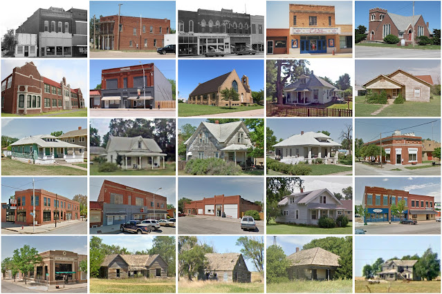
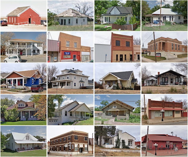
Edwards County, Kansas

Image
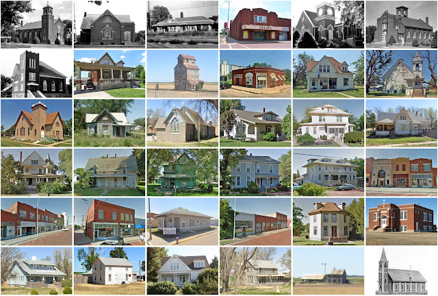
Founding:  1874 Parent county:  Kiowa Namesake:  W.C. Edwards, local resident Seat:  Kinsley (1874–) Land area:  622 square miles Population (2020):  2,907 Population (historic):  2,409 (1880); 3,682 (1900); 7,295 (1930) Periods of population growth:  pre-1880–1930 Subdivisions:  Four cities; ten townships National Register listings:   Three Pre-1940 residences (estimated):  658 (40.6%) Pre-1940 housing survival rate:  41.8% Farm housing in disrepair (1950):  4.2% Nonfarm housing in disrepair (1950):  4.8% Average farmhouse value (1930):  $1,202 Average outbuilding value (1930):  $1,259 Average farmhouse size (1940):  5.8 rooms Number of farms (1920):  805 Average farm size (1920):  384.1 acres Sources of settlement:  Kansas, Missouri, Illinois, Indiana, Ohio, and Iowa _________________________________________________________________________________   Kinsley   Namesake:  Edward Kinsley, Massachusetts businessman Founding:  1873 (platting as Peters ); 1873 (post office); 1878 (incorpor

Jewell County, Kansas

Image
Founding:  1870 (declared in 1867) Parent county:  Unorganized territory Namesake:  Lewis Jewell, Kansas soldier Seat:  Mankato (1870–) Land area:  910 square miles Population (2020):  2,932 Population (historic):  17,475 (1870); 19,349 (1890); 18,148 (1910); 14,462 (1930) Periods of population growth:  1870–1900 Subdivisions:  Seven cities; 25 townships National Register listings:   Six Pre-1940 residences (estimated):  937 (46.5%) Pre-1940 housing survival rate:  29.6% Farm housing in disrepair (1950):  7.5% Nonfarm housing in disrepair (1950):  7.4% Average farmhouse value (1930):  $1,062 Average outbuilding value (1930):  $933 Average farmhouse size (1940):  6.1 rooms Number of farms (1920):  2,740 Average farm size (1920):  164.6 acres Sources of settlement:  Iowa, Illinois, Ohio, Indiana, Pennsylvania, and New York _________________________________________________________________________________   Mankato   Namesake:  Mankato, Minnesota Founding:  1872 (platting as Jewell Center

Neosho County, Kansas

Image
Founding:  1864 (declared in 1861) Parent county:  Unorganized territory Namesake:  The Neosho River Seat:  St. Paul (1864–1872); Erie (1872–) Land area:  571 square miles Population (2020):  15,904 Population (historic):  10,206 (1870); 18,561 (1890); 23,754 (1910); 22,665 (1930) Periods of population growth:  1860–1920 Subdivisions:  Seven cities; 12 townships National Register listings:   Nine Pre-1940 residences (estimated):  2,533 (32.7%) Pre-1940 housing survival rate:  40.1% Farm housing in disrepair (1950):  7.4% Nonfarm housing in disrepair (1950):  7.4% Average farmhouse value (1930):  $1,020 Average outbuilding value (1930):  $758 Average farmhouse size (1940):  5.5 rooms Number of farms (1920):  2,160 Average farm size (1920):  120.3 acres Sources of settlement:  Illinois, Indiana, Ohio, Missouri, and Kentucky _________________________________________________________________________________   Erie   Namesake:  Lake Erie Founding:  1866 (platting); 1866 (post office); 1869 (

Clark County, Kansas

Image
Founding:  1885 (declared in 1867) Parent county:  Unorganized territory Namesake:  Charles Clarke, Kansas soldier Seat:  Ashland (1885–) Land area:  975 square miles Population (2020):  1,991 Population (historic):  2,357 (1890); 4,093 (1910); 4,796 (1930) Periods of population growth:  1880s; 1900–1920 Subdivisions:  Three cities; six townships National Register listings:   Seven Pre-1940 residences (estimated):  417 (35.6%) Pre-1940 housing survival rate:  39.1% Farm housing in disrepair (1950):   10.2% Nonfarm housing in disrepair (1950):  11.4% Average farmhouse value (1930):  $1,057 Average outbuilding value (1930):  $854 Average farmhouse size (1940):  5.2 rooms Number of farms (1920):  624 Average farm size (1920):  324.8 acres Sources of settlement:  Kansas, Missouri, Indiana, Illinois, Oklahoma, Ohio, Iowa, and Kentucky _________________________________________________________________________________   Ashland   Namesake:  Ashland, Kentucky Founding:  1884 (platting); 1885 (p

Comanche County, Kansas

Image
Founding:  1885 (declared in 1867) Parent county:  Unorganized territory Namesake:  The Comanche tribe Seat:  Coldwater (1885–) Land area:  788 square miles Population (2020):  1,689 Population (historic):  2,549 (1890); 3,281 (1910); 5,238 (1930) Periods of population growth:  1880s; 1900–1920 Subdivisions:  Three cities; four townships National Register listings:   Four Pre-1940 residences (estimated):  520 (49.9%) Pre-1940 housing survival rate:  42.3% Farm housing in disrepair (1950):  11.6% Nonfarm housing in disrepair (1950):  5% Average farmhouse value (1930):  $1,517 Average outbuilding value (1930):  $1,460 Average farmhouse size (1940):  5.4 rooms Number of farms (1920):  570 Average farm size (1920):  379.4 acres Sources of settlement:  Kansas, Missouri, Ohio, Illinois, Indiana, and Oklahoma _________________________________________________________________________________   Coldwater   Namesake:  Coldwater, Michigan Founding:  1884 (platting); 1884 (post office); 1885 (incor

Hodgeman County, Kansas

Image
Founding:  1879 (declared in 1867) Parent county:  Unorganized territory Namesake:  Amos Hodgeman, Kansas soldier Seat:  Jetmore (1879–) Land area:  860 square miles Population (2020):  1,723 Population (historic):  1,704 (1880); 2,032 (1900); 4,157 (1930) Periods of population growth:  pre-1880–1890; 1900–1930 Subdivisions:  Two cities; nine townships National Register listings:   Four Pre-1940 residences (estimated):  277 (29.1%) Pre-1940 housing survival rate:  31.9% Farm housing in disrepair (1950):  7.2% Nonfarm housing in disrepair (1950):  5.2% Average farmhouse value (1930):  $1,170 Average outbuilding value (1930):  $1,149 Average farmhouse size (1940):  5.1 rooms Number of farms (1920):  641 Average farm size (1920):  302.6 acres Sources of settlement:  Kansas, Illinois, Missouri, Iowa, Ohio, and Germany _________________________________________________________________________________   Jetmore   Namesake:  Abraham Jetmore, railroad developer Founding:  1879 (platting); 1880

Saratoga County, New York

Image
Founding:  1791 Parent county:  Albany Namesake:  An Iroquois word meaning "the hill beside the river" Seat:  Stillwater (1791–1796); Ballston (1796–1817); Ballston Spa (1817–) Land area:  810 square miles Population (2020):  235,509 Population (historic):  24,483 (1800); 40,553 (1840); 51,529 (1870); 61,089 (1900); 63,314 (1930) Periods of population growth:  pre-1800–1860; 1870–1910; 1920–2020 Subdivisions:  Two cities; ten villages; six CDPs; 19 towns National Register listings:   80 Pre-1940 residences (estimated):  17,478 (16.3%) Pre-1940 housing survival rate:  81.4% Pre-1860 housing survival rate (1940):  28.5% Farm housing in disrepair (1950):  8.2% Nonfarm housing in disrepair (1950):  5.2% Average farmhouse value (1930):  $1,955 Average outbuilding value (1930):  $1,551 Average farmhouse size (1940):  7.6 rooms Number of farms (1920):  3,178 Average farm size (1920):  63.2 acres _________________________________________________________________________________   Ball

Sterling County, Texas

Image
Founding:  1891 Parent county:  Tom Green Namesake:  W.S. Sterling, local rancher Seat:  Sterling City (1891–) Land area:  923 square miles Population (2020):  1,372 Population (historic):  1,127 (1900); 1,493 (1910); 1,053 (1920); 1,431 (1930) Periods of population growth:  pre-1900–1910; 1920s; 1970–1990; 2010s Subdivisions:  One city National Register listings:  0 Pre-1940 residences (estimated):  52 (9.1%) Pre-1940 housing survival rate:  35.2% Farm housing in disrepair (1950):  8.8% Nonfarm housing in disrepair (1950):  24.8% Average farmhouse value (1930):  $1,344 Average outbuilding value (1930):  $1,029 Average farmhouse size (1940):  4.5 rooms Number of farms (1920):  131 Average farm size (1920):  65.7 acres _________________________________________________________________________________   Sterling City   Namesake:  W.S. Sterling, local rancher Founding:  1891 (platting); 1891 (post office); 1955 (incorporation) Population (2020):  1,121 Periods of population growth:  pre-19

Roberts County, Texas

Image
Founding:  1889 (declared in 1876) Parent county:  Unorganized territory Namesake:  Oran Roberts, Texas governor Seat:  Miami (1889–) Land area:  924 square miles Population (2020):  827 Population (historic):  326 (1890); 950 (1910); 1,457 (1930) Periods of population growth:  1880–1920; 1950s; 1970s; 2000s Subdivisions:  One city National Register listings:   One Pre-1940 residences (estimated):  136 (30.6%) Pre-1940 housing survival rate:  36.5% Farm housing in disrepair (1950):  1.5% Nonfarm housing in disrepair (1950):  1.3% Average farmhouse value (1930):  $1,706 Average outbuilding value (1930):  $1,484 Average farmhouse size (1940):  4.3 rooms Number of farms (1920):  152 Average farm size (1920):  290.2 acres Sources of settlement:  Texas and Oklahoma _________________________________________________________________________________   Miami   Namesake:  Uncertain—perhaps the Miami tribe Founding:  1887 (platting); 1887 (post office) Population (2020):  539 Population (historic)

Motley County, Texas

Image
Founding:  1891 (declared in 1876) Parent county:  Unorganized territory Namesake:  Junius Mottley, early Texas resident Seat:  Matador (1891–) Land area:  990 square miles Population (2020):  1,063 Population (historic):  1,257 (1900); 2,396 (1910); 4,107 (1920); 6,812 (1930) Periods of population growth:  1890–1930 Subdivisions:  Two towns National Register listings:   One Pre-1940 residences (estimated):  324 (41.5%) Pre-1940 housing survival rate:  13.5% Farm housing in disrepair (1950):  36.9% Nonfarm housing in disrepair (1950):  23.9% Average farmhouse value (1930):  $605 Average outbuilding value (1930):  $433 Average farmhouse size (1940):  3.5 rooms Number of farms (1920):  537 Average farm size (1920):  115.5 acres Sources of settlement:  Texas, Oklahoma, and Arkansas _________________________________________________________________________________   Matador   Namesake:  The nearby Matador Ranch Founding:  1886 (post office); 1891 (platting); 1912 (incorporation) Population