Posts

Showing posts from August, 2019

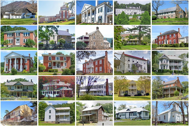
Rappahannock County, Virginia

Image
Founding:  1833 Parent county:  Culpeper Namesake:  The Rappahannock River Seat:  Washington (1833–) Land area:  266 square miles Population (2020):  7,348 Population (historic):  9,257 (1840); 8,850 (1860); 9,291 (1880); 8,843 (1900); 7,717 (1930) Periods of population growth:  pre-1840–1850; 1870s; 1890s; 1970–2010 Subdivisions:  One town; three CDPs National Register listings:   19 Pre-1940 residences (estimated):  1,072 (27.2%) Pre-1940 housing survival rate:  51.4% Pre-1860 housing survival rate (1940):  26% Farm housing in disrepair (1950):  35.7% Nonfarm housing in disrepair (1950):  24.4% Average farmhouse value (1930):  $1,500 Average outbuilding value (1930):  $942 Average farmhouse size (1940):  5.5 rooms Number of farms (1920):  949 Average farm size (1920):  107.9 acres _________________________________________________________________________________ Washington Namesake:  George Washington, U.S. president Founding:  1749 (platting); 1795

Eaton County, Michigan

Image
Founding:  1837 Parent county:  Unorganized territory Namesake:  John Eaton, Tennessee politician Seat:  Bellevue (1837–1840); Charlotte (1840–) Land area:  575 square miles Population (2020):  109,175 Population (historic):  2,379 (1840); 16,476 (1860); 31,225 (1880); 31,668 (1900); 31,728 (1930) Periods of population growth:  pre-1840–1890; 1920–2020 Subdivisions:  Five cities; five villages; one CDP; 16 townships National Register listings:   17 Pre-1940 residences (estimated):  7,353 (15.5%) Pre-1940 housing survival rate:  76.3% Pre-1860 housing survival rate (1940):  10.3% Farm housing in disrepair (1950):  7.8% Nonfarm housing in disrepair (1950):  6.4% Average farmhouse value (1930):  $1,571 Average outbuilding value (1930):  $1,612 Number of farms (1920):  3,719 Average farm size (1920):  71 acres Sources of settlement:  New York, Ohio, and Pennsylvania _________________________________________________________________________________ Charlotte

Bath County, Virginia

Image
Founding:  1791 Parent counties:  Augusta, Botetourt, and Greenbrier Namesake:  Bath, England Seat:  Warm Springs (1791–) Land area:  529 square miles Population (2020):  4,209 Population (historic):  5,508 (1800); 4,300 (1840); 3,795 (1870); 5,595 (1900); 8,137 (1930) Periods of population growth:  pre-1800; 1810s; 1830s; 1850–1910; 1920s; 1970s; 1990s Subdivisions:  Two CDPs National Register listings:   25 Pre-1940 residences (estimated):  821 (24.5%) Pre-1940 housing survival rate:  48.7% Pre-1860 housing survival rate (1940):  15% Farm housing in disrepair (1950):  14.1% Nonfarm housing in disrepair (1950):  21% Average farmhouse value (1930):  $2,237 Average outbuilding value (1930):  $1,125 Average farmhouse size (1940):  6.2 rooms Number of farms (1920):  639 Average farm size (1920):  65.3 acres _________________________________________________________________________________ Warm Springs Namesake:  Mineral springs within the village Foundin

Webster County, West Virginia

Image
Founding:  1860 Parent counties:  Braxton, Nicholas, and Randolph Namesake:  Daniel Webster, Massachusetts politician Seat:  Webster Springs (1860–) Land area:  553 square miles Population (2020):  8,378 Population (historic):  1,555 (1860); 3,207 (1880); 8,862 (1900); 14,216 (1930) Periods of population growth:  pre-1860–1940; 1970s Subdivisions:  Three towns; two CDPs National Register listings:   Seven Pre-1940 residences (estimated):  731 (13.4%) Pre-1940 housing survival rate:  21.8% Pre-1860 housing survival rate (1940):  4.8% Farm housing in disrepair (1950):  26.5% Nonfarm housing in disrepair (1950):  18.2% Average farmhouse value (1930):  $587 Average outbuilding value (1930):  $239 Average farmhouse size (1940):  4.7 rooms Number of farms (1920):  981 Average farm size (1920):  39.1 acres _________________________________________________________________________________ Webster Springs Namesake:  Webster County Founding:  1860 (platting as

Wayne County, West Virginia

Image
Founding:  1842 Parent county:  Cabell Namesake:  Anthony Wayne, Continental Army officer Seat:  Wayne (1842–) Land area:  506 square miles Population (2020):  38,982 Population (historic):  4,760 (1850); 7,852 (1870); 18,652 (1890); 24,081 (1910); 31,206 (1930) Periods of population growth:  pre-1850–1960; 1970s; 1990s Subdivisions:  One city; three towns; three CDPs National Register listings:   Seven Pre-1940 residences (estimated):  1,803 (9.3%) Pre-1940 housing survival rate:  31.7% Pre-1860 housing survival rate (1940):  9.4% Farm housing in disrepair (1950):  15.3% Nonfarm housing in disrepair (1950):  20.2% Average farmhouse value (1930):  $555 Average outbuilding value (1930):  $278 Average farmhouse size (1940):  4.4 rooms Number of farms (1920):  3,058 Average farm size (1920):  44.2 acres _________________________________________________________________________________ Wayne Namesake:  Anthony Wayne, Continental Army officer Founding:  18

Boone County, West Virginia

Image
Founding:  1847 Parent counties:  Cabell, Kanawha, and Logan Namesake:  Daniel Boone, explorer Seat:  Madison (1847–) Land area:  502 square miles Population (2020):  21,809 Population (historic):  3,237 (1850); 4,553 (1870); 6,885 (1890); 10,331 (1910); 24,586 (1930) Periods of population growth:  pre-1850–1860; 1870–1950; 1970s Subdivisions:  One city; three towns; five CDPs National Register listings:   Four Pre-1940 residences (estimated):  1,294 (11.6%) Pre-1940 housing survival rate:  24.1% Pre-1860 housing survival rate (1940):  2.4% Farm housing in disrepair (1950):  36.4% Nonfarm housing in disrepair (1950):  25.1% Average farmhouse value (1930):  $812 Average outbuilding value (1930):  $274 Average farmhouse size (1940):  4.6 rooms Number of farms (1920):  1,120 Average farm size (1920):  24 acres _________________________________________________________________________________ Madison Namesake:  Unclear—perhaps James Madison, U.S. president

Mercer County, West Virginia

Image
Founding:  1837 Parent counties:  Giles and Tazewell Namesake:  Hugh Mercer, Continental Army general Seat:  Princeton (1838–) Land area:  419 square miles Population (2020):  59,664 Population (historic):  2,233 (1840); 6,819 (1860); 7,467 (1880); 23,023 (1900); 61,323 (1930) Periods of population growth:  pre-1840–1950; 1970s Subdivisions:  Two cities; four towns; seven CDPs National Register listings:   18 Pre-1940 residences (estimated):  4,791 (16%) Pre-1940 housing survival rate:  34.9% Pre-1860 housing survival rate (1940):  4.3% Farm housing in disrepair (1950):  22% Nonfarm housing in disrepair (1950):  13.5% Average farmhouse value (1930):  $1,132 Average outbuilding value (1930):  $451 Average farmhouse size (1940):  5 rooms Number of farms (1920):  1,927 Average farm size (1920):  52 acres _________________________________________________________________________________ Princeton Namesake:  Princeton, New Jersey Founding:  1838 (platting)

Hardy County, West Virginia

Image
Founding:  1786 Parent county:  Hampshire Namesake:  Samuel Hardy, Virginia politician Seat:  Moorefield (1786–) Land area:  582 square miles Population (2020):  14,299 Population (historic):  7,336 (1790); 7,622 (1840); 5,518 (1870); 8,449 (1900); 9,816 (1930) Periods of population growth:  pre-1790; 1810–1860; 1870–1940; 1970–2020 Subdivisions:  Two towns National Register listings:   25 Pre-1940 residences (estimated):  1,061 (12.9%) Pre-1940 housing survival rate:  49.8% Pre-1860 housing survival rate (1940):  16.5% Farm housing in disrepair (1950):  18% Nonfarm housing in disrepair (1950):  20.5% Average farmhouse value (1930):  $1,017 Average outbuilding value (1930):  $643 Average farmhouse size (1940):  5.7 rooms Number of farms (1920):  1,228 Average farm size (1920):  84.9 acres _________________________________________________________________________________ Moorefield Namesake:  Conrad Moore, owner of the town site Founding:  1777 (platti

Marion County, West Virginia

Image
Founding:  1842 Parent counties:  Harrison and Monongalia Namesake:  Francis Marion, Continental Army officer Seat:  Fairmont (1842–) Land area:  309 square miles Population (2020):  56,205 Population (historic):  10,552 (1850); 12,107 (1870); 20,721 (1890); 42,794 (1910); 66,655 (1930) Periods of population growth:  pre-1850–1860; 1870–1950; 1970s Subdivisions:  Three cities; eight towns; three CDPs National Register listings:   22 Pre-1940 residences (estimated):  7,756 (29.4%) Pre-1940 housing survival rate:  47% Pre-1860 housing survival rate (1940):  15.2% Farm housing in disrepair (1950):  18.5% Nonfarm housing in disrepair (1950):  10.2% Average farmhouse value (1930):  $1,295 Average outbuilding value (1930):  $585 Average farmhouse size (1940):  5 rooms Number of farms (1920):  2,233 Average farm size (1920):  52.7 acres _________________________________________________________________________________ Fairmont Namesake:  A reference to the cit

Lewis County, West Virginia

Image
Founding:  1816 Parent county:  Harrison Namesake:  Charles Lewis, Virginia soldier Seat:  Weston (1818–) Land area:  385 square miles Population (2020):  17,033 Population (historic):  4,247 (1820); 10,031 (1850); 13,269 (1880); 16,980 (1900); 21,794 (1930) Periods of population growth:  pre-1820–1850; 1860–1940; 1970s; 2010s Subdivisions:  One city; one town National Register listings:   13 Pre-1940 residences (estimated):  1,731 (21.8%) Pre-1940 housing survival rate:  43.8% Pre-1860 housing survival rate (1940):  8.9% Farm housing in disrepair (1950):  19.8% Nonfarm housing in disrepair (1950):  9.9% Average farmhouse value (1930):  $1,175 Average outbuilding value (1930):  $527 Average farmhouse size (1940):  5.8 rooms Number of farms (1920):  1,644 Average farm size (1920):  109.5 acres _________________________________________________________________________________ Weston Namesake:  Unknown Founding:  1818 (platting as Preston ); 1820 (post o

Mingo County, West Virginia

Image
Founding:  1895 Parent county:  Logan Namesake:  The Mingo tribe Seat:  Williamson (1895–) Land area:  423 square miles Population (2020):  23,568 Population (historic):  11,359 (1900); 19,431 (1910); 26,384 (1920); 38,319 (1930) Periods of population growth:  pre-1900–1950; 1970s Subdivisions:  One city; four towns; four CDPs National Register listings:   Eight Pre-1940 residences (estimated):  1,017 (7.9%) Pre-1940 housing survival rate:  15.7% Farm housing in disrepair (1950):  29.6% Nonfarm housing in disrepair (1950):  22.4% Average farmhouse value (1930):  $573 Average outbuilding value (1930):  $219 Average farmhouse size (1940):  3.8 rooms Number of farms (1920):  898 Average farm size (1920):  25.2 acres _________________________________________________________________________________ Williamson Namesake:  Wallace Williamson, owner of the city site Founding:  1892 (post office); 1892 (incorporation) Population ( 2020 ):  3,083 Population (

Logan County, West Virginia

Image
Founding:  1824 Parent counties:  Cabell, Giles, Kanawha, and Tazewell Namesake:  Logan, Iroquois orator Seat:  Logan (1826–) Land area:  454 square miles Population (2020):  32,567 Population (historic):  3,680 (1830); 4,938 (1860); 7,329 (1880); 6,955 (1900); 58,534 (1930) Periods of population growth:  pre-1830–1840; 1850–1890; 1900–1950; 1970s Subdivisions:  One city; four towns; 20 CDPs National Register listings:   Four Pre-1940 residences (estimated):  2,489 (14.8%) Pre-1940 housing survival rate:  18.1% Pre-1860 housing survival rate (1940):  3.2% Farm housing in disrepair (1950):  32.7% Nonfarm housing in disrepair (1950):  19.7% Average farmhouse value (1930):  $384 Average outbuilding value (1930):  $181 Average farmhouse size (1940):  3.8 rooms Number of farms (1920):  768 Average farm size (1920):  28.1 acres _________________________________________________________________________________ Logan Namesake:  Logan, Iroquois orator Founding

Wyoming County, West Virginia

Image
Founding:  1850 Parent county:  Logan Namesake:  Unclear Seat:  Oceana (1850–1907); Pineville (1907–) Land area:  499 square miles Population (2020):  21,382 Population (historic):  1,645 (1850); 3,171 (1870); 6,247 (1890); 10,392 (1910); 20,926 (1930) Periods of population growth:  pre-1850–1860; 1870–1950; 1970s Subdivisions:  One city; two towns; nine CDPs National Register listings:   Four Pre-1940 residences (estimated):  1,297 (11.9%) Pre-1940 housing survival rate:  21.9% Pre-1860 housing survival rate (1940):  1.1% Farm housing in disrepair (1950):  28.4% Nonfarm housing in disrepair (1950):  17.5% Average farmhouse value (1930):  $540 Average outbuilding value (1930):  $189 Average farmhouse size (1940):  4.1 rooms Number of farms (1920):  1,181 Average farm size (1920):  33 acres _________________________________________________________________________________ Pineville Namesake:  The region's pine forests Founding:  1876 (post office);

Braxton County, West Virginia

Image
Founding:  1836 Parent counties:  Kanawha, Lewis, Nicholas, and Randolph Namesake:  Carter Braxton, Virginia politician Seat:  Sutton (1836–) Land area:  511 square miles Population (2020):  12,447 Population (historic):  2,575 (1840); 4,992 (1860); 9,787 (1880); 18,904 (1900); 22,579 (1930) Periods of population growth:  pre-1840–1920; 1970s; 1990s Subdivisions:  Four towns National Register listings:   10 Pre-1940 residences (estimated):  1,224 (16.5%) Pre-1940 housing survival rate:  25.7% Pre-1860 housing survival rate (1940):  4.6% Farm housing in disrepair (1950):  32.5% Nonfarm housing in disrepair (1950):  20.4% Average farmhouse value (1930):  $669 Average outbuilding value (1930):  $327 Average farmhouse size (1940):  4.9 rooms Number of farms (1920):  2,599 Average farm size (1920):  64.4 acres _________________________________________________________________________________ Sutton Namesake:  John Sutton, owner of the town site Founding: