Posts

Showing posts from February, 2022

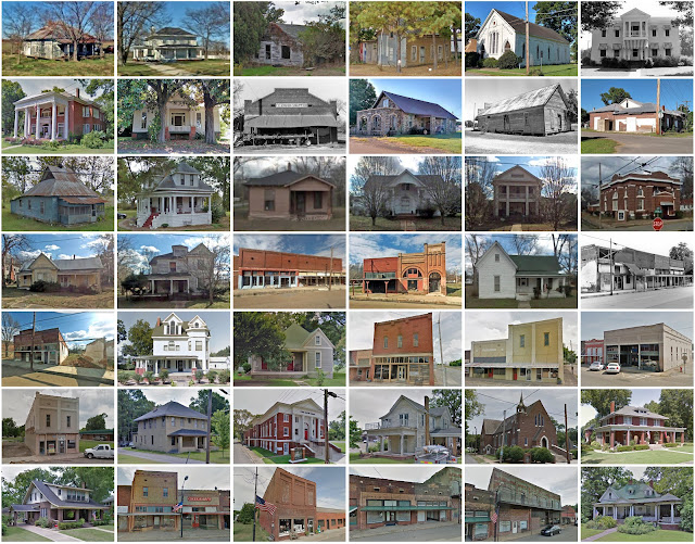
Wise County, Virginia

Image
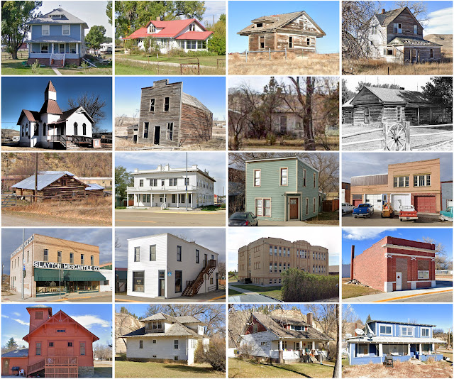
Founding:  1856 Parent counties:  Lee, Russell, and Scott Namesake:  Henry Wise, Virginia governor Seat:  Wise (1856–) Land area:  403 square miles Population (2020):  36,130 Population (historic):  4,508 (1860); 7,772 (1880); 19,653 (1900); 51,167 (1930) Periods of population growth:  pre-1860–1950; 1970s; 1990–2010 Subdivisions:  One city; six towns; eight CDPs National Register listings:   20 (plus one in Norton) Pre-1940 residences (estimated):  2,001 (11.1%) Pre-1940 housing survival rate:  20.3% Pre-1860 housing survival rate (1940):  4.6% Farm housing in disrepair (1950):  21.1% Nonfarm housing in disrepair (1950):  21.2% Average farmhouse value (1930):  $820 Average outbuilding value (1930):  $311 Average farmhouse size (1940):  4.3 rooms Number of farms (1920):  1,067 Average farm size (1920):  33.2 acres _________________________________________________________________________________   Wise   Namesake:  Henry Wise, Virginia governor Founding:  1856 (founding as Gladeville

Woodruff County, Arkansas

Image
Founding:  1862 Parent counties:  Jackson and St. Francis Namesake:  William Woodruff, Arkansas politician Seat:  Augusta (1862–) Land area:  587 square miles Population (2020):  6,269 Population (historic):  6,891 (1870); 14,009 (1890); 20,049 (1910); 22,682 (1930) Periods of population growth:  pre-1870–1930 Subdivisions:  Four cities; one town National Register listings:   18 Pre-1940 residences (estimated):  190 (4.9%) Pre-1940 housing survival rate:  6.7% Farm housing in disrepair (1950):  48.7% Nonfarm housing in disrepair (1950):  38.2% Average farmhouse value (1930):  $339 Average outbuilding value (1930):  $136 Average farmhouse size (1940):  3.7 rooms Number of farms (1920):  2,853 Average farm size (1920):  36.6 acres Sources of settlement:  Arkansas, Mississippi, Tennessee, Alabama, Georgia, and North Carolina _________________________________________________________________________________   Augusta   Namesake:  A niece of the city's founder Founding:  1848 (platting);

Cimarron County, Oklahoma

Image
Founding:  1907 Parent county:  Beaver Namesake:  The Cimarron River Seat:  Kenton (1907–1908); Boise City (1908–) Land area:  1,835 square miles Population (2020):  2,296 Population (historic):  4,553 (1910); 3,436 (1920); 5,408 (1930) Periods of population growth:  pre-1910; 1920s; 1940s Subdivisions:  One city; one town; two CDPs National Register listings:   Eight Pre-1940 residences (estimated):  318 (20.1%) Pre-1940 housing survival rate:  30.9% Farm housing in disrepair (1950):  9.5% Nonfarm housing in disrepair (1950):  5.6% Average farmhouse value (1930):  $755 Average outbuilding value (1930):  $632 Average farmhouse size (1940):  3.9 rooms Number of farms (1920):  767 Average farm size (1920):  126.7 acres _________________________________________________________________________________   Boise City   Namesake:  Uncertain—perhaps Boise, Idaho Founding:  1908 (platting); 1908 (post office); 1925 (incorporation) Population (2020):  1,166 Population (historic):  1,256 (1930); 1

Tolland County, Connecticut

Image
Founding:  1785 Parent counties:  Hartford and Windham Namesake:  The town of Tolland Seat:  Tolland (1785–1889); Rockville (1889–1960) Land area:  410 square miles Population (2020):  149,788 Population (historic):  13,251 (1790); 17,980 (1840); 22,000 (1870); 24,523 (1900); 28,659 (1930) Periods of population growth:  pre-1790–1800; 1810–1830; 1840–1890; 1900–2010 Subdivisions:  13 towns National Register listings:   51 Pre-1940 residences (estimated):  10,529 (17.5%) Pre-1940 housing survival rate:  80.7% Pre-1860 housing survival rate (1940):  39.5% Farm housing in disrepair (1950):  6.2% Nonfarm housing in disrepair (1950):  3.9% Average farmhouse value (1930):  $2,472 Average outbuilding value (1930):  $1,944 Average farmhouse size (1940):  6.9 rooms Number of farms (1920):  1,977 Average farm size (1920):  26.8 acres _________________________________________________________________________________   Tolland  (ex-seat)   Namesake:  Uncertain—perhaps Tolland, England Founding:  17

Prince Edward County, Virginia

Image
Founding:  1754 Parent county:  Amelia Namesake:  Prince Edward, Duke of York and Albany Seat:   Worsham (1754–1872); Farmville (1872–) Land area:  350 square miles Population (2020):  21,849 Population (historic):  8,100 (1790); 14,069 (1840); 12,004 (1870); 15,045 (1900); 14,520 (1930) Periods of population growth:  pre-1790–1830; 1860–1900; 1910s; 1930–1950; 1960–2010 Subdivisions:  One town; one CDP National Register listings:   15 Pre-1940 residences (estimated):  996 (10.6%) Pre-1940 housing survival rate:  29.6% Pre-1860 housing survival rate (1940):  32.7% Farm housing in disrepair (1950):  24.2% Nonfarm housing in disrepair (1950):  16.8% Average farmhouse value (1930):  $882 Average outbuilding value (1930):  $444 Average farmhouse size (1940):  4.9 rooms Number of farms (1920):  1,843 Average farm size (1920):  38.7 acres _________________________________________________________________________________   Farmville   Namesake:  Uncertain Founding:  1798 (founding); 1800 (post

Treasure County, Montana

Image
Founding:  1919 Parent county:  Rosebud Namesake:  A promotional name Seat:  Hysham (1919–) Land area:  977 square miles Population (2020):  762 Population (historic):  1,990 (1920); 1,661 (1930); 1,499 (1940) Periods of population growth:  pre-1920; 2010s Subdivisions:  One town National Register listings:   Three Pre-1940 residences (estimated):  104 (22.2%) Pre-1940 housing survival rate:  34% Farm housing in disrepair (1950):  19.4% Nonfarm housing in disrepair (1950):  10.6% Average farmhouse value (1930):  $739 Average outbuilding value (1930):  $671 Average farmhouse size (1940):  3.8 rooms Number of farms (1920):  330 Average farm size (1920):  136.2 acres _________________________________________________________________________________   Hysham   Namesake:  Charles Hysham, local rancher Founding:  1907 (post office); 1908 (platting); 1916 (incorporation) Population (2020):  276 Population (historic):  360 (1920); 258 (1930); 392 (1940) Periods of population growth:  pre-1920;

Golden Valley County, Montana

Image
Founding:  1920 Parent counties:  Musselshell and Sweet Grass Namesake:  A descriptive name Seat:  Ryegate (1920–) Land area:  1,175 square miles Population (2020):  827 Population (historic):  2,126 (1930); 1,607 (1940) Periods of population growth:  pre-1930; 1970s; 1990s Subdivisions:  Two towns; one CDP National Register listings:   Five Pre-1940 residences (estimated):  160 (33.5%) Pre-1940 housing survival rate:  35.4% Farm housing in disrepair (1950):  5.5% Nonfarm housing in disrepair (1950):  7.2% Average farmhouse value (1930):  $686 Average outbuilding value (1930):  $680 Average farmhouse size (1940):  4.7 rooms Number of farms (1930):  387 _________________________________________________________________________________   Ryegate   Namesake:  A reference to rye fields near the town site Founding:  1908 (platting); 1908 (post office) Population (2020):  223 Population (historic):  405 (1920); 292 (1930); 348 (1940) Periods of population growth:  pre-1920; 1930s; 1970s; 1990

Amador County, California

Image
Founding:  1854 Parent counties:  Calaveras and El Dorado Namesake:  José María Amador, California rancher Seat:  Jackson (1854–) Land area:  595 square miles Population (2020):  40,474 Population (historic):  10,930 (1860); 11,384 (1880); 11,116 (1900); 8,494 (1930) Periods of population growth:  pre-1860; 1870s; 1890s; 1920–2020 Subdivisions:  Five cities; 13 CDPs National Register listings:   21 Pre-1940 residences (estimated):  1,722 (9.4%) Pre-1940 housing survival rate:  47.6% Pre-1860 housing survival rate (1940):  2.3% Farm housing in disrepair (1950):  16.2% Nonfarm housing in disrepair (1950):  11.3% Average farmhouse value (1930):  $1,149 Average outbuilding value (1930):  $1,033 Average farmhouse size (1940):  5.4 rooms Number of farms (1920):  479 Average farm size (1920):  125.2 acres Sources of settlement:  Italy, England, Austria, Ireland, Missouri, Germany, Ohio, New York, and Illinois _________________________________________________________________________________  

Lane County, Kansas

Image
Founding:  1886 (declared in 1873) Parent county:  Unorganized territory Namesake:  James Lane, Union Army general Seat:  Dighton (1886–) Land area:  717 square miles Population (2020):  1,574 Population (historic):  604 (1880); 1,563 (1900); 3,372 (1930) Periods of population growth:  pre-1880–1890; 1900–1930; 1950s Subdivisions:  One city; one CDP; five townships National Register listings:   Three Pre-1940 residences (estimated):  277 (28.6%) Pre-1940 housing survival rate:  39.5% Farm housing in disrepair (1950):  3.8% Nonfarm housing in disrepair (1950):  2.1% Average farmhouse value (1930):  $1,190 Average outbuilding value (1930):  $1,181 Average farmhouse size (1940):  5.1 rooms Number of farms (1920):  473 Average farm size (1920):  643.3 acres Sources of settlement:  Kansas, Missouri, Illinois, Iowa, Ohio, and Indiana _________________________________________________________________________________   Dighton   Namesake:  Richard Deighton, owner of the city site Founding:  187

Wallace County, Kansas

Image
Founding:  1889 (declared in 1868) Parent county:  Unorganized territory Namesake:  William Wallace, Union Army general Seat:  Sharon Springs (1889–) Land area:  914 square miles Population (2020):  1,512 Population (historic):  538 (1870); 2,468 (1890); 2,759 (1910); 2,882 (1930) Periods of population growth:  pre-1870–1890; 1900s; 1920s; 1940s; 1960s; 2010s Subdivisions:  Two cities; one CDP; four townships National Register listings:   Three Pre-1940 residences (estimated):  261 (33.4%) Pre-1940 housing survival rate:  35.2% Farm housing in disrepair (1950):  13.8% Nonfarm housing in disrepair (1950):  4.8% Average farmhouse value (1930):  $898 Average outbuilding value (1930):  $901 Average farmhouse size (1940):  4.5 rooms Number of farms (1920):  341 Average farm size (1920):  297.3 acres Sources of settlement:  Kansas, Iowa, Illinois, Missouri, Nebraska, Indiana, Ohio, and Sweden _________________________________________________________________________________   Sharon Springs