Posts

Showing posts with the label marshall county

Marshall County, Iowa
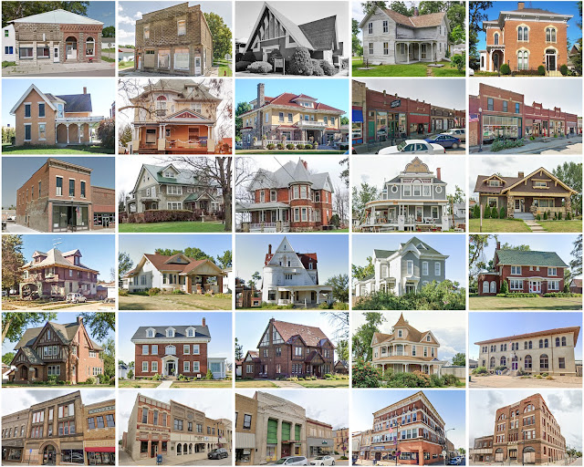
Image
Founding:  1849 (declared in 1846) Parent county:  Unorganized territory Namesake:  John Marshall, Supreme Court chief justice Seat:   Marietta (1851–1863); Marshalltown (1863–) Land area:  572 square miles Population (2020):  40,105 Population (historic):  338 (1850); 17,576 (1870); 25,842 (1890); 30,279 (1910); 33,727 (1930) Periods of population growth:  1850–1980; 1990–2010 Subdivisions:  14 cities; one CDP; 16 townships Pre-1940 residences (estimated):  5,686 (33.9%) Pre-1940 housing survival rate:  59.8% Farm housing in disrepair (1950):  3.1% Nonfarm housing in disrepair (1950):  7% Average farmhouse value (1930):  $2,688 Average outbuilding value (1930):  $3,240 Average farmhouse size (1940):  7 rooms Number of farms (1920):  2,315 Average farm size (1920):  138.3 acres Sources of settlement:  Ohio, Illinois, New York, Pennsylvania, Indiana, and Germany ________________________________...

Marshall County, Kansas

Image
Founding:  1855 Parent county:  Unorganized territory Namesake:  Frank Marshall, prominent local resident Seat:  Marysville (1855–) Land area:  900 square miles Population (2020):  10,038 Population (historic):  768 (1870); 20,539 (1890); 23,880 (1910); 23,056 (1930) Periods of population growth:  1860–1900 Subdivisions:  Nine cities; one CDP; 25 townships Pre-1940 residences (estimated):  1,857 (37.9%) Pre-1940 housing survival rate:  39.5% Farm housing in disrepair (1950):  13.1% Nonfarm housing in disrepair (1950):  6.6% Average farmhouse value (1930):  $1,659 Average outbuilding value (1930):  $1,517 Average farmhouse size (1940):  6.3 rooms Number of farms (1920):  2,798 Average farm size (1920):  155.2 acres Sources of settlement:  Illinois, Ohio, New York, Germany, Pennsylvania, Iowa, Indiana, and Missouri _______________________________________________________...

Marshall County, Indiana

Image
Founding:  1836 (declared in 1835) Parent counties:  St. Joseph and unorganized territory Namesake:  John Marshall, Supreme Court chief justice Seat:  Plymouth (1836–) Land area:  444 square miles Population (2020):  46,095 Population (historic):  1,651 (1840); 12,722 (1860); 23,414 (1880); 25,119 (1900); 25,077 (1930) Periods of population growth:  pre-1840–1900; 1920–2010 Subdivisions:  One city; five towns; ten townships Pre-1940 residences (estimated):  5,200 (25.9%) Pre-1940 housing survival rate:  62.3% Pre-1860 housing survival rate (1940):  8.8% Farm housing in disrepair (1950):  4.8% Nonfarm housing in disrepair (1950):  5.4% Average farmhouse value (1930):  $1,383 Average outbuilding value (1930):  $1,392 Average farmhouse size (1940):  6.7 rooms Number of farms (1920):  2,720 Average farm size (1920):  77.2 acres Sources of settlement:  Ohio, Pennsylvan...

Marshall County, Illinois

Image
Founding:  1839 Parent county:  Putnam Namesake:  John Marshall, Supreme Court chief justice Seat:  Lacon (1839–) Land area:  387 square miles Population (2020):  11,742 Population (historic):  1,849 (1840); 13,437 (1860); 15,055 (1880); 16,370 (1900); 13,023 (1930) Periods of population growth:  pre-1840–1870; 1890s; 1930s; 1950s; 1970s; 1990s Subdivisions:  Four cities; five villages; 12 townships Pre-1940 residences (estimated):  1,735 (29.4%) Pre-1940 housing survival rate:  57.7% Pre-1860 housing survival rate (1940):  10.3% Farm housing in disrepair (1950):  2.9% Nonfarm housing in disrepair (1950):  4.4% Average farmhouse value (1930):  $2,128 Average outbuilding value (1930):  $2,347 Average farmhouse size (1940):  6.9 rooms Number of farms (1920):  1,231 Average farm size (1920):  150.4 acres Sources of settlement:  Germany, Ohio, Pennsylvania, New York, ...

Marshall County, Kentucky

Image
Founding:  1842 Parent county:  Calloway Namesake:  John Marshall, Supreme Court chief justice Seat:  Benton (1842–) Land area:  301 square miles Population (2020):  31,659 Population (historic):  5,269 (1850); 9,455 (1870); 11,287 (1890); 15,771 (1910); 12,889 (1930) Periods of population growth:  pre-1850–1910; 1930s; 1950–2020 Subdivisions:  Three cities; one CDP Pre-1940 residences (estimated):  526 (3.3%) Pre-1940 housing survival rate:  17.4% Pre-1860 housing survival rate (1940):  2.3% Farm housing in disrepair (1950): 12.9% Nonfarm housing in disrepair (1950): 10% Average farmhouse value (1930):  $398 Average outbuilding value (1930):  $203 Average farmhouse size (1940):  3.7 rooms Number of farms (1920):  3,353 Average farm size (1920):  39 acres _________________________________________________________________________________ Benton Namesake:  Thomas Benton...

Marshall County, West Virginia

Image
Founding:  1835 Parent county:  Ohio Namesake:  John Marshall, Supreme Court chief justice Seat:  Moundsville (1835–) Land area:  305 square miles Population (2020):  30,591 Population (historic):  6,937 (1840); 14,941 (1870); 26,444 (1900); 39,841 (1930) Periods of population growth:  pre-1840–1940; 1950s; 1970s Subdivisions:  Five cities Pre-1940 residences (estimated):  4,147 (26.3%) Pre-1940 housing survival rate:  50.7% Pre-1860 housing survival rate (1940):  10.2% Farm housing in disrepair (1950):  22.7% Nonfarm housing in disrepair (1950):  8.9% Average farmhouse value (1930):  $1,364 Average outbuilding value (1930):  $915 Average farmhouse size (1940):  5.6 rooms Number of farms (1920):  1,712 Average farm size (1920):  74.9 acres _________________________________________________________________________________ Moundsville Namesake:  The Grave Cree...