Posts

Showing posts with the label greene county

Greene County, Iowa

Image
Founding:  1854 (declared in 1851) Parent county:  Unorganized territory Namesake:  Nathanael Greene, Continental Army general Seat:  Jefferson (1856–) Land area:  570 square miles Population (2020):  8,771 Population (historic):  1,374 (1860); 12,727 (1880); 17,820 (1900); 16,528 (1930) Periods of population growth:  pre-1860–1900; 1910–1940; 1990s Subdivisions:  Eight cities; 16 townships Pre-1940 residences (estimated):  1,810 (39.8%) Pre-1940 housing survival rate:  44.6% Farm housing in disrepair (1950):  3.9% Nonfarm housing in disrepair (1950):  3.5% Average farmhouse value (1930):  $2,162 Average outbuilding value (1930):  $2,732 Average farmhouse size (1940):  6.6 rooms Number of farms (1920):  2,059 Average farm size (1920):  148.5 acres Sources of settlement:  Illinois, Ohio, New York, Pennsylvania, and Indiana ________________________________________________________________________...
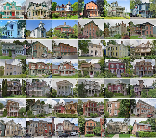
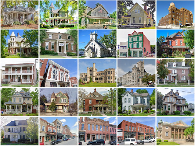
Greene County, New York

Image
Founding:  1800 Parent counties:  Albany and Ulster Namesake:  Nathanael Greene, Continental Army general Seat:  Catskill (1800–) Land area:  647 square miles Population (2020):  47,931 Population (historic):  12,584 (1800); 30,446 (1840); 31,832 (1870); 31,478 (1900); 25,808 (1930) Periods of population growth:  pre-1800–1850; 1870s; 1930–2010 Subdivisions:  Five villages; 15 CDPs; 14 towns Pre-1940 residences (estimated):  8,758 (29.5%) Pre-1940 housing survival rate:  82.4% Pre-1860 housing survival rate (1940):  39.3% Farm housing in disrepair (1950):  8.8% Nonfarm housing in disrepair (1950):  6% Average farmhouse value (1930):  $2,874 Average outbuilding value (1930):  $1,888 Average farmhouse size (1940):  7.8 rooms Number of farms (1920):  2,248 Average farm size (1920):  73 acres _________________________________________________________________________________ Catskill Namesake: ...

Greene County, Missouri

Image
Founding:  1833 Parent county:  Unorganized territory Namesake:  Nathanael Greene, Continental Army general Seat:  Springfield (1834–) Land area:  675 square miles Population (2020):  298,915 Population (historic):  5,372 (1840); 13,186 (1860); 28,801 (1880); 52,713 (1900); 82,929 (1930) Periods of population growth:  pre-1840–2020 Subdivisions:  Eight cities Pre-1940 residences (estimated):  11,746 (8.7%) Pre-1940 housing survival rate:  45% Pre-1860 housing survival rate (1940):  5.6% Farm housing in disrepair (1950):  7.6% Nonfarm housing in disrepair (1950):  5.8% Average farmhouse value (1930):  $1,375 Average outbuilding value (1930):  $925 Average farmhouse size (1940):  4.5 rooms Number of farms (1920):  4,252 Average farm size (1920):  71 acres Sources of settlement:  Missouri, Tennessee, Kentucky, Arkansas, North Carolina, Illinois, and Ohio _____________________________________...

Greene County, Virginia

Image
  Founding:  1838 Parent county:  Orange Namesake:  Nathanael Greene, Continental Army general Seat:  Stanardsville (1838–) Land area:  156 square miles Population (2020):  20,552 Population (historic):  4,232 (1840); 5,022 (1860); 5,830 (1880); 6,214 (1900); 5,980 (1930) Periods of population growth:  pre-1840–1860; 1870s; 1890–1910; 1960–2020 Subdivisions:  One town; two CDPs Pre-1940 residences (estimated):  479 (5.8%) Pre-1940 housing survival rate:  47.8% Pre-1860 housing survival rate (1940):  18.3% Farm housing in disrepair (1950):  20.4% Nonfarm housing in disrepair (1950):  24.5% Average farmhouse value (1930):  $881 Average outbuilding value (1930):  $487 Average farmhouse size (1940):  5.4 rooms Number of farms (1920):  834 Average farm size (1920):  56.6 acres _________________________________________________________________________________ Stanardsville Namesake:  Willia...

Greene County, Illinois

Image
Founding:  1821 Parent county:  Madison Namesake:  Nathanael Greene, Continental Army general Seat:  Carrollton (1821–) Land area:  543 square miles Population (2020):  11,985 Population (historic):  7,674 (1830); 16,093 (1860); 23,010 (1880); 23,402 (1900); 20,417 (1930) Periods of population growth:  pre-1830–1890; 1910s Subdivisions:  Four cities; five villages; 13 townships Pre-1940 residences (estimated):  2,725 (42.6%) Pre-1940 housing survival rate:  49.6% Pre-1860 housing survival rate (1940):  11% Farm housing in disrepair (1950):  7.8% Nonfarm housing in disrepair (1950):  7.9% Average farmhouse value (1930):  $1,455 Average outbuilding value (1930):  $1,224 Average farmhouse size (1940):  5.7 rooms Number of farms (1920):  2,143 Average farm size (1920):  120.6 acres Sources of settlement:  Kentucky, Missouri, Tennessee, Ohio, Ireland, and Germany ____...

Greene County, Pennsylvania

Image
Founding:  1796 Parent county:  Washington Namesake:  Nathanael Greene, Continental Army general Seat:  Waynesburg (1796–) Land area:  576 square miles Population (2020):  35,954 Population (historic):  8,605 (1800); 19,147 (1840); 25,887 (1870); 28,281 (1900); 41,767 (1930) Periods of population growth:  pre-1800–1890; 1900–1950; 1970–1990 Subdivisions:  Six boroughs; 14 CDPs; 20 townships Pre-1940 residences (estimated):  5,263 (31.6%) Pre-1940 housing survival rate:  51.8% Pre-1860 housing survival rate (1940):  22.2% Farm housing in disrepair (1950):  19% Nonfarm housing in disrepair (1950):  10.9% Average farmhouse value (1930):  $1,955 Average outbuilding value (1930):  $1,115 Average farmhouse size (1940):  6 rooms Number of farms (1920):  3,168 Average farm size (1920):  95 acres _________________________________________________________________________________...

Greene County, Indiana

Image
Founding:  1821 Parent counties:  Sullivan and unorganized territory Namesake:  Nathanael Greene, Continental Army general Seat:   Burlington (1821–1824); Bloomfield (1824–) Land area:  543 square miles Population (2020):  30,803 Population (historic):  4,242 (1830); 16,041 (1860); 22,996 (1880); 28,530 (1900); 31,481 (1930) Periods of population growth:  pre-1820–1910; 1960–2000 Subdivisions:  Two cities; five towns; two CDPs; 15 townships Pre-1940 residences (estimated):  3,066 (20.1%) Pre-1940 housing survival rate:  38.7% Pre-1860 housing survival rate (1940):  6% Farm housing in disrepair (1950): 9.3% Nonfarm housing in disrepair (1950): 7.9% Average farmhouse value (1930):  $751 Average outbuilding value (1930):  $543 Average farmhouse size (1940):  4.5 rooms Number of farms (1920):  3,441 Average farm size (1920):  69.1 acres Sources of settlement:  Ohio, Kentucky, P...

Greene County, Ohio

Image
Founding:  1803 Parent counties:  Hamilton and Ross Namesake:  Nathanael Greene, Continental Army general Seat:  Xenia (1804–) Land area:  414 square miles Population (2020):  167,966 Population (historic):  5,870 (1810); 21,946 (1850); 31,649 (1880); 31,613 (1900); 33,259 (1930) Periods of population growth:  pre-1810–1880; 1890s; 1910–2020 Subdivisions:  Four cities; six villages; three CDPs; 12 townships Pre-1940 residences (estimated):  6,503 (9.5%) Pre-1940 housing survival rate:  59.9% Pre-1860 housing survival rate (1940):  30.3% Farm housing in disrepair (1950):  4.8% Nonfarm housing in disrepair (1950):  6.6% Average farmhouse value (1930):  $1,973 Average outbuilding value (1930):  $1,582 Average farmhouse size (1940):  6.8 rooms Number of farms (1920):  2,373 Average farm size (1920):  90.1 acres Sources of settlement:  Virginia, Pennsylvania, Kentucky...