Posts

Showing posts from July, 2020

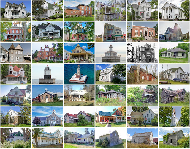
Marquette County, Michigan

Image
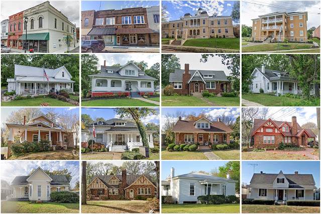
Founding:  1851 (declared in 1843) Parent counties:  Chippewa and Mackinac Namesake:  Jacques Marquette, Jesuit missionary Seat:  Marquette (1850s–) Land area:  1,808 square miles Population (2020):  66,017 Population (historic):  2,821 (1860); 25,394 (1880); 41,239 (1900); 44,076 (1930) Periods of population growth:  1850–1910; 1930–1980; 2000s Subdivisions:  Three cities; nine CDPs; 19 townships National Register listings:   41 Pre-1940 residences (estimated):  6,535 (18.7%) Pre-1940 housing survival rate:  68% Farm housing in disrepair (1950):  7.8% Nonfarm housing in disrepair (1950):  7.2% Average farmhouse value (1930):  $901 Average outbuilding value (1930):  $944 Average farmhouse size (1940):  4.9 rooms Number of farms (1920):  846 Average farm size (1920):  33 acres Sources of settlement:  Canada, Sweden, Finland, France, New York, Germany, England, and Ireland _________________________________________________________________________________ Ma

Aransas County, Texas

Image
Founding:  1871 Parent county:  Refugio Namesake:  Aransas Bay Seat:  Rockport (1872–) Land area:  252 square miles Population (2020):  23,830 Population (historic):  966 (1880); 1,716 (1900); 2,219 (1930) Periods of population growth:  pre-1880–1890; 1900s; 1920–2020 Subdivisions:  One city; one town; two CDPs National Register listings:   Five Pre-1940 residences (estimated):  312 (1.9%) Pre-1940 housing survival rate:  24.9% Farm housing in disrepair (1950):  15.4% Nonfarm housing in disrepair (1950):  16.3% Average farmhouse value (1930):  $979 Average outbuilding value (1930):  $469 Average farmhouse size (1940):  3.8 rooms Number of farms (1920):  59 Average farm size (1920):  55 acres _________________________________________________________________________________ Rockport Namesake:  A traditional name Founding:  1867 (platting); 1868 (post office); 1870 (incorporation) Population (2020):  10,070 Population (historic):  1,069 (1890); 1,15

Winkler County, Texas

Founding:  1910 (declared in 1887) Parent county:  Tom Green Namesake:  Clinton Winkler, Texas politician Seat:  Kermit (1910–) Land area:  841 square miles Population (2020):  7,791 Population (historic):  442 (1910); 81 (1920); 6,784 (1930) Periods of population growth:  1890–1910; 1920s; 1940–1960; 1970s; 2010s Subdivisions:  Two cities National Register listings:   One Pre-1940 residences (estimated):  14 (0.5%) Pre-1940 housing survival rate:  6.7% Farm housing in disrepair (1950):  12.8% Nonfarm housing in disrepair (1950):  10.7% Average farmhouse value (1930):  $638 Average outbuilding value (1930):  $1,145 Average farmhouse size (1940):  3.8 rooms Number of farms (1920):  27 Average farm size (1920):  13.6 acres Sources of settlement:  Texas, Missouri, Oklahoma, Louisiana, and Arkansas _________________________________________________________________________________ Kermit Namesake:  Uncertain—perhaps Kermit Roosevelt, son of Theodore Rooseve

Telfair County, Georgia

Image
Founding:  1807 Parent county:  Wilkinson Namesake:  Edward Telfair, Georgia governor Seat:  Jacksonville (1807–1871); McRae (1871–) Land area:  437 square miles Population (2020):  12,477 Population (historic):  744 (1810); 2,763 (1840); 3,245 (1870); 10,083 (1900); 14,997 (1930) Periods of population growth:  pre-1810–1850; 1860–1920; 1930s; 1990–2010 Subdivisions:  Four cities; one town National Register listings:   Three Pre-1940 residences (estimated):  631 (8.7%) Pre-1940 housing survival rate:  13.4% Pre-1860 housing survival rate (1940):  4.5% Farm housing in disrepair (1950):  38% Nonfarm housing in disrepair (1950):  28.1% Average farmhouse value (1930):  $401 Average outbuilding value (1930):  $189 Average farmhouse size (1940):  4.1 rooms Number of farms (1920):  1,897 Average farm size (1920):  45.9 acres _________________________________________________________________________________ McRae Namesake:  Daniel McRae, owner of the city site

Houghton County, Michigan

Image
Founding:  1846 (declared in 1845) Parent county:  Marquette Namesake:  Douglass Houghton, Michigan geologist Seat:  Eagle River (1846–1861); Houghton (1861–) Land area:  1,009 square miles Population (2020):  37,361 Population (historic):  708 (1850); 13,879 (1870); 35,389 (1890); 88,098 (1910); 52,851 (1930) Periods of population growth:  pre-1850–1910; 1970s; 1990–2020 Subdivisions:  Two cities; five villages; two CDPs; 14 townships National Register listings:   43 Pre-1940 residences (estimated):  7,695 (41%) Pre-1940 housing survival rate:  64.5% Pre-1860 housing survival rate (1940):  1.9% Farm housing in disrepair (1950):  18.5% Nonfarm housing in disrepair (1950):  11% Average farmhouse value (1930):  $671 Average outbuilding value (1930):  $677 Average farmhouse size (1940):  5 rooms Number of farms (1920):  1,741 Average farm size (1920):  32.6 acres Sources of settlement:  Sweden, Finland, England, Canada, France, Wisconsin, Germany, Austria, and

Talbot County, Georgia

Image
Founding:  1827 Parent counties:  Muscogee and Troup Namesake:  Matthew Talbot, Georgia governor Seat:  Talbotton (1828–) Land area:  391 square miles Population (2020):  5,733 Population (historic):  5,940 (1830); 13,616 (1860); 14,115 (1880); 12,197 (1900); 8,458 (1930) Periods of population growth:  1821–1850; 1870s; 2000s Subdivisions:  Two cities; two towns National Register listings:   12 Pre-1940 residences (estimated):  402 (11.8%) Pre-1940 housing survival rate:  14.9% Pre-1860 housing survival rate (1940):  11.3% Farm housing in disrepair (1950):  33.5% Nonfarm housing in disrepair (1950):  34.3% Average farmhouse value (1930):  $451 Average outbuilding value (1930):  $227 Average farmhouse size (1940):  4 rooms Number of farms (1920):  1,635 Average farm size (1920):  44.4 acres _________________________________________________________________________________ Talbotton Namesake:  Matthew Talbot, Georgia governor Founding:  1828 (platting)

Montcalm County, Michigan

Image
Founding:  1850 (declared in 1831) Parent county:  Unorganized territory Namesake:  Louis-Joseph de Montcalm, French army general Seat:  Greenville (1850–1860); Stanton (1860–) Land area:  705 square miles Population (2020):  66,614 Population (historic):  891 (1850); 13,629 (1870); 32,754 (1890); 32,069 (1910); 27,471 (1930) Periods of population growth:  pre-1850–1880; 1930–2020 Subdivisions:  Three cities; six villages; 20 townships National Register listings:   Three Pre-1940 residences (estimated):  4,878 (17.2%) Pre-1940 housing survival rate:  56.8% Pre-1860 housing survival rate (1940):  10.6% Farm housing in disrepair (1950):  13.1% Nonfarm housing in disrepair (1950):  10.3% Average farmhouse value (1930):  $1,363 Average outbuilding value (1930):  $1,354 Average farmhouse size (1940):  6.5 rooms Number of farms (1920):  4,493 Average farm size (1920):  59.9 acres Sources of settlement:  New York, Michigan, Ohio, Canada, Pennsylvania, Denmark, and

Charlevoix County, Michigan

Image
Founding:  1869 Parent county:  Emmet Namesake:  Pierre François Xavier de Charlevoix, French-Canadian priest Seat:  Charlevoix (1869–1884, 1897–); East Jordan (1884–1886); Boyne City (1886–1897) Land area:  416 square miles Population (2020):  26,054 Population (historic):  1,724 (1870); 9,686 (1890); 19,157 (1910); 11,981 (1930) Periods of population growth:  pre-1870–1910; 1930–1950; 1960–2000 Subdivisions:  Three cities; one village; seven CDPs; 15 townships National Register listings:   24 Pre-1940 residences (estimated):  2,299 (13%) Pre-1940 housing survival rate:  69.8% Farm housing in disrepair (1950):  14.2% Nonfarm housing in disrepair (1950):  10.8% Average farmhouse value (1930):  $891 Average outbuilding value (1930):  $740 Average farmhouse size (1940):  5.8 rooms Number of farms (1920):  1,306 Average farm size (1920):  49.6 acres Sources of settlement:  Michigan, New York, and Canada __________________________________________________________

Cheboygan County, Michigan

Image
Founding:  1853 (declared in 1840) Parent county:  Mackinac Namesake:  The Cheboygan River Seat:  Cheboygan (1853–) Land area:  715 square miles Population (2020):  25,579 Population (historic):  517 (1860); 6,524 (1880); 15,516 (1900); 11,502 (1930) Periods of population growth:  pre-1860–1910; 1930–2000 Subdivisions:  One city; two villages; one CDP; 19 townships National Register listings:   10 Pre-1940 residences (estimated):  2,708 (14.7%) Pre-1940 housing survival rate:  53.3% Pre-1860 housing survival rate (1940):  2.8% Farm housing in disrepair (1950):  24.3% Nonfarm housing in disrepair (1950):  13.5% Average farmhouse value (1930):  $723 Average outbuilding value (1930):  $663 Average farmhouse size (1940):  5.6 rooms Number of farms (1920):  1,186 Average farm size (1920):  47.2 acres Sources of settlement:  Michigan, Canada, France, New York, Poland, Germany, and Ohio ______________________________________________________________________________

St. Clair County, Michigan

Image
Founding:  1821 (declared in 1820) Parent county:  Macomb Namesake:  The St. Clair River Seat:  St. Clair (1821–1871); Port Huron (1871–) Land area:  721 square miles Population (2020):  160,383 Population (historic):  1,114 (1830); 26,604 (1860); 46,197 (1880); 55,228 (1900); 67,563 (1930) Periods of population growth:  pre-1830–1900; 1910–2000 Subdivisions:  Eight cities; two villages; one CDP; 23 townships National Register listings:   26 Pre-1940 residences (estimated):  12,452 (17.2%) Pre-1940 housing survival rate:  54.7% Pre-1860 housing survival rate (1940):  9.4% Farm housing in disrepair (1950):  7.5% Nonfarm housing in disrepair (1950):  5.2% Average farmhouse value (1930):  $1,621 Average outbuilding value (1930):  $1,454 Average farmhouse size (1940):  6.7 rooms Number of farms (1920):  4,159 Average farm size (1920):  74.9 acres Sources of settlement:  Canada, Germany, New York, Ireland, and England ____________________________________________

Missaukee County, Michigan

Image
Founding:  1871 (declared in 1840) Parent county:  Unorganized territory Namesake:  Lake Missaukee Seat:  Lake City (1873–) Land area:  565 square miles Population (2020):  15,052 Population (historic):  1,553 (1880); 9,308 (1900); 6,992 (1930) Periods of population growth:  1870–1910; 1930s; 1960–2020 Subdivisions:  Two cities; one CDP; 16 townships National Register listings:   Two Pre-1940 residences (estimated):  989 (10.7%) Pre-1940 housing survival rate:  55.7% Farm housing in disrepair (1950):  16.5% Nonfarm housing in disrepair (1950):  9.2% Average farmhouse value (1930):  $969 Average outbuilding value (1930):  $1,039 Average farmhouse size (1940):  5.9 rooms Number of farms (1920):  1,359 Average farm size (1920):  57.7 acres Sources of settlement:  Michigan, Canada, Holland, New York, and Sweden _________________________________________________________________________________ Lake City Namesake:  Lake Missaukee Founding:  circa 1872 (foun

Clare County, Michigan

Image
Founding:  1871 (declared in 1840) Parent county:  Unorganized territory Namesake:  County Clare, Ireland Seat:  Farwell (1871–1879); Harrison (1879–) Land area:  564 square miles Population (2020):  30,856 Population (historic):  4,187 (1880); 8,360 (1900); 7,032 (1930) Periods of population growth:  1870–1910; 1930–2000 Subdivisions:  Two cities; one village; 16 townships National Register listings:   Three Pre-1940 residences (estimated):  1,341 (5.8%) Pre-1940 housing survival rate:  51.4% Farm housing in disrepair (1950):  11.9% Nonfarm housing in disrepair (1950):  5.7% Average farmhouse value (1930):  $959 Average outbuilding value (1930):  $958 Number of farms (1920):  1,248 Average farm size (1920):  52.7 acres Sources of settlement:  Michigan, Canada, New York, and Pennsylvania _________________________________________________________________________________ Harrison Namesake:  Uncertain—perhaps William Henry Harrison, U.S. president Foundi

Otsego County, Michigan

Image
Founding:  1875 (declared in 1840) Parent county:  Unorganized territory Namesake:  Uncertain—perhaps Otsego Lake or Otsego County, New York Seat:  Otsego Lake (1875–1877); Gaylord (1877–) Land area:  514 square miles Population (2020):  25,091 Population (historic):  1,974 (1880); 6,175 (1900); 5,554 (1930) Periods of population growth:  pre-1880–1910; 1930–2020 Subdivisions:  One city; one village; nine townships National Register listings:   Three Pre-1940 residences (estimated):  811 (5.5%) Pre-1940 housing survival rate:  49.3% Farm housing in disrepair (1950):  6.7% Nonfarm housing in disrepair (1950):  4.2% Average farmhouse value (1930):  $690 Average outbuilding value (1930):  $658 Average farmhouse size (1940):  5.7 rooms Number of farms (1920):  573 Average farm size (1920):  57.4 acres Sources of settlement:  Michigan, Canada, New York, and Poland _________________________________________________________________________________ Gaylord Nam

Presque Isle County, Michigan

Image
Founding:  1871 (declared in 1840) Parent county:  Unorganized territory Namesake:  Presque Isle Seat:  Rogers City (1871–) Land area:  659 square miles Population (2020):  12,982 Population (historic):  3,113 (1880); 8,821 (1900); 11,330 (1930) Periods of population growth:  1860–1920; 1930s; 1950s; 1970s; 1990s Subdivisions:  Two cities; two villages; one CDP; 14 townships National Register listings:   15 Pre-1940 residences (estimated):  1,372 (13.1%) Pre-1940 housing survival rate:  56.5% Farm housing in disrepair (1950):  21.3% Nonfarm housing in disrepair (1950):  7.1% Average farmhouse value (1930):  $931 Average outbuilding value (1930):  $885 Number of farms (1920):  1,056 Average farm size (1920):  48.1 acres Sources of settlement:  Michigan, Canada, Germany, and Poland _________________________________________________________________________________ Rogers City Namesake:  William Rogers, owner of the city site Founding:  1869 (platting);

Iosco County, Michigan

Image
Founding:  1857 (declared in 1840) Parent county:  Unorganized territory Namesake:  Uncertain—perhaps a Native American word or a Henry Schoolcraft neologism Seat:  Tawas City (1857–) Land area:  549 square miles Population (2020):  25,237 Population (historic):  3,163 (1870); 15,224 (1890); 9,753 (1910); 7,517 (1930) Periods of population growth:  1860–1890; 1930–1990 Subdivisions:  Three cities; three CDPs; 11 townships National Register listings:   Four Pre-1940 residences (estimated):  1,732 (8.4%) Pre-1940 housing survival rate:  51.8% Farm housing in disrepair (1950):  14.8% Nonfarm housing in disrepair (1950):  2.8% Average farmhouse value (1930):  $883 Average outbuilding value (1930):  $985 Number of farms (1920):  929 Average farm size (1920):  53.5 acres Sources of settlement:  Michigan, Canada, New York, Germany, France, Sweden, and Finland _________________________________________________________________________________ Tawas City Namesak

Chester County, Tennessee

Image
Founding:  1882 Parent counties:  Hardeman, Henderson, Madison, and McNairy Namesake:  Robert Chester, Tennessee politician Seat:  Henderson (1882–) Land area:  286 square miles Population (2020):  17,341 Population (historic):  9,069 (1890); 9,090 (1910); 10,603 (1930) Periods of population growth:  pre-1890–1900; 1910–1950; 1960–2020 Subdivisions:  One city; three towns National Register listings:   Three Pre-1940 residences (estimated):  327 (4.6%) Pre-1940 housing survival rate:  13.1% Farm housing in disrepair (1950):  42.9% Nonfarm housing in disrepair (1950):  18.3% Average farmhouse value (1930):  $401 Average outbuilding value (1930):  $159 Average farmhouse size (1940):  3.9 rooms Number of farms (1920):  1,667 Average farm size (1920):  37.6 acres _________________________________________________________________________________ Henderson Namesake:  Henderson County, Tennessee Founding:  1857 (platting) Population (2020):  6,308 Populat