Posts

Showing posts from May, 2019

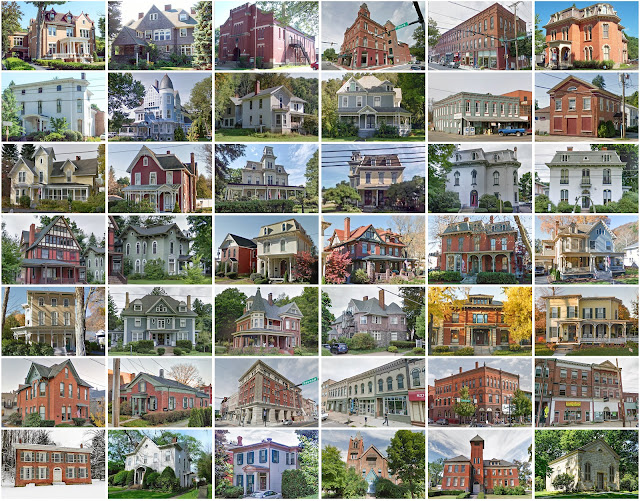
Surry County, Virginia

Image
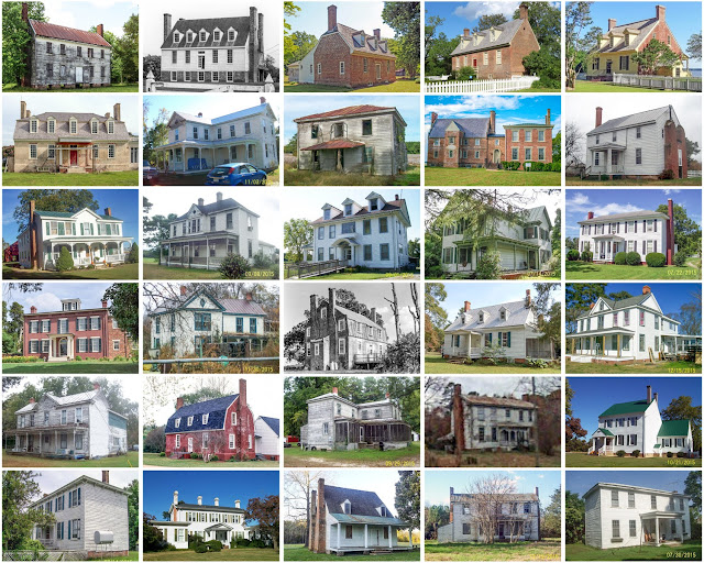
Founding:  1652 Parent county:  James City Namesake:  Surrey, England Seat:  Surry (1797–) Land area:  279 square miles Population (2020):  6,561 Population (historic):  6,227 (1790); 7,109 (1830); 6,133 (1860); 8,256 (1890); 7,096 (1930) Periods of population growth:  pre-1790–1810; 1820s; 1850s; 1870–1910; 1970–2010 Subdivisions:  Three towns; one CDP National Register listings:   20 Pre-1940 residences (estimated):  481 (13.6%) Pre-1940 housing survival rate:  33.4% Pre-1860 housing survival rate (1940):  14.2% Farm housing in disrepair (1950):  25.8% Nonfarm housing in disrepair (1950):  24% Average farmhouse value (1930):  $1,102 Average outbuilding value (1930):  $550 Average farmhouse size (1940):  5.4 rooms Number of farms (1920):  1,140 Average farm size (1920):  32.8 acres _________________________________________________________________________________ Surry Namesake:  Surry County Founding:  1797 (founding); 1797 (post office) Popu

Page County, Virginia

Image
Founding:  1831 Parent counties:  Rockingham and Shenandoah Namesake:  John Page, Virginia governor Seat:  Luray (1831–) Land area:  311 square miles Population (2020):  23,709 Population (historic):  6,194 (1840); 8,109 (1860); 9,965 (1880); 13,794 (1900); 14,852 (1930) Periods of population growth:  pre-1840–2010 Subdivisions:  Three towns National Register listings:   34 Pre-1940 residences (estimated):  2,436 (20.8%) Pre-1940 housing survival rate:  61.7% Pre-1860 housing survival rate (1940:  20.9% Farm housing in disrepair (1950):  10% Nonfarm housing in disrepair (1950):  8.6% Average farmhouse value (1930):  $1,337 Average outbuilding value (1930):  $728 Average farmhouse size (1940):  6.4 rooms Number of farms (1920):  1,280 Average farm size (1920):  57 acres _________________________________________________________________________________ Luray Namesake:  Luray, France Founding:  1803 (post office); 1812 (platting); 1871 (incorporatio

Glascock County, Georgia

Image
Founding:  1857 Parent county:  Warren Namesake:  Thomas Glascock, Georgia politician Seat:  Gibson (1858–) Land area:  144 square miles Population (2020):  2,884 Population (historic):  2,437 (1860); 3,577 (1880); 4,516 (1900); 4,388 (1930) Periods of population growth:  pre-1860–1910; 1920–1940; 1970s; 1990–2010 Subdivisions:  Two cities; one town National Register listings:   One Pre-1940 residences (estimated):  195 (12.8%) Pre-1940 housing survival rate:  17.1% Pre-1860 housing survival rate (1940):  5.7% Farm housing in disrepair (1950):  45.7% Nonfarm housing in disrepair (1950):  44.5% Average farmhouse value (1930):  $376 Average outbuilding value (1930):  $159 Average farmhouse size (1940):  4.2 rooms Number of farms (1920):  675 Average farm size (1920):  51.2 acres _________________________________________________________________________________ Gibson Namesake:  William Gibson, who funded the Glascock County Courthouse's construction

Essex County, Vermont

Image
Founding:  1800 (declared in 1792) Parent county:  Orange Namesake:  Essex, England Seat:  Guildhall (1800–) Land area:  664 square miles Population (2020):  5,920 Population (historic):  1,479 (1800); 3,981 (1830); 5,786 (1860); 9,511 (1890); 7,067 (1930) Periods of population growth:  pre-1800–1890; 1970–2000 Subdivisions:  Four CDPs; 16 towns; three gores National Register listings:   11 Pre-1940 residences (estimated):  1,317 (25.7%) Pre-1940 housing survival rate:  69.6% Pre-1860 housing survival rate (1940):  29.5% Farm housing in disrepair (1950):  21.4% Nonfarm housing in disrepair (1950):  11.7% Average farmhouse value (1930):  $1,392 Average outbuilding value (1930):  $1,421 Average farmhouse size (1940):  7 rooms Number of farms (1920):  671 Average farm size (1920):  57.8 acres _________________________________________________________________________________ Guildhall Namesake:  Unclear Founding:  1780s (founding); 1805 (post office) P

Arlington County, Virginia

Image
Founding:  1801 (as Alexandria County ) Parent county:  Fairfax Namesake:  Arlington House Seat:  Alexandria (1801–1870); Arlington (1870–) Land area:  26 square miles Population (2020):  238,643 Population (historic):  5,949 (1800); 9,573 (1830); 12,652 (1860); 6,430 (1900); 26,615 (1930) Periods of population growth:  pre-1800–1820; 1830–1970; 1980–2020 Subdivisions:  None National Register listings:   70  (plus 50 in Alexandria) Pre-1940 residences (estimated):  10,136 (9.1%) Pre-1940 housing survival rate:  60.5% Housing in disrepair (1950):  1% Average farmhouse value (1930):  $4,813 Average outbuilding value (1930):  $2,981 Number of farms (1920):  56 Average farm size (1920):  32.4 acres _________________________________________________________________________________ Alexandria  (historic) Namesake:  Alexandria, Egypt Founding:  1749 (platting); 1779 (incorporation) Population (2020):  159,467 Population (historic):  2,748 (1790); 8,218 (18

Henry County, Indiana

Image
Founding:  1822 Parent county:  Unorganized territory Namesake:  Patrick Henry, Virginia politician Seat:  New Castle (1823–) Land area:  392 square miles Population (2010):  49,462 Population (historic):  6,497 (1830); 20,119 (1860); 24,016 (1880); 25,088 (1900); 35,238 (1930) Periods of population growth:  pre-1830–1870; 1900–1920; 1930–1950 Subdivisions:  One city; 15 towns; 13 townships National Register listings:   13 Pre-1940 residences (estimated):  5,790 (27.3%) Pre-1940 housing survival rate:  56.9% Pre-1860 housing survival rate (1940):  16.1% Farm housing in disrepair (1950): 2.8% Nonfarm housing in disrepair (1950): 6.6% Average farmhouse value (1930):  $1,622 Average outbuilding value (1930):  $1,548 Average farmhouse size (1940):  6.7 rooms Number of farms (1920):  2,540 Average farm size (1920):  83.1 acres Sources of settlement:  Ohio, North Carolina, Virginia, and Pennsylvania _________________________________________________________________

Cole County, Missouri

Image
Founding:  1821 Parent county:  Cooper Namesake:  Stephen Cole, Missouri settler Seat:  Jefferson City (1821–) Land area:  394 square miles Population (2020):  77,279 Population (historic):  3,023 (1830); 9,697 (1860); 15,515 (1880); 20,578 (1900); 30,848 (1930) Periods of population growth:  pre-1830–1840; 1850–2020 Subdivisions:  Six cities; two villages; six townships National Register listings:   53 Pre-1940 residences (estimated):  3,390 (10.3%) Pre-1940 housing survival rate:  41.2% Pre-1860 housing survival rate (1940):  11.5% Farm housing in disrepair (1950):  10.2% Nonfarm housing in disrepair (1950):  4% Average farmhouse value (1930):  $1,389 Average outbuilding value (1930):  $1,145 Average farmhouse size (1940):  5 rooms Number of farms (1920):  1,621 Average farm size (1920):  86.9 acres Sources of settlement:  Germany, Kentucky, Tennessee, and Ohio ______________________________________________________________________________ Jefferson City

Taylor County, West Virginia

Image
Founding:  1844 Parent counties:  Barbour, Harrison, and Marion Namesake:  Unclear—perhaps John Taylor or Zachary Taylor Seat:  Pruntytown (1844–1878); Grafton (1878–) Land area:  173 square miles Population (2020):  16,705 Population (historic):  5,367 (1850); 9,367 (1870); 14,978 (1900); 19,114 (1930) Periods of population growth:  pre-1850–1940; 1970s; 1990–2010 Subdivisions:  One city; one town National Register listings:   Six Pre-1940 residences (estimated):  1,746 (23.2%) Pre-1940 housing survival rate:  37.7% Pre-1860 housing survival rate (1940):  16.2% Farm housing in disrepair (1950):  24.9% Nonfarm housing in disrepair (1950):  21.7% Average farmhouse value (1930):  $1,248 Average outbuilding value (1930):  $477 Average farmhouse size (1940):  5.1 rooms Number of farms (1920):  996 Average farm size (1920):  63 acres _________________________________________________________________________________ Grafton Namesake:  Unknown Founding:  18

Monroe County, West Virginia

Image
Founding:  1799 Parent county:  Greenbrier Namesake:  James Monroe, U.S. president Seat:  Union (1800–) Land area:  473 square miles Population (2020):  12,376 Population (historic):  4,188 (1800); 7,798 (1830); 10,757 (1860); 12,429 (1890); 11,949 (1930) Periods of population growth:  pre-1800–1900; 1930s; 1970s; 1990s Subdivisions:  Two towns National Register listings:   26 Pre-1940 residences (estimated):  1,213 (15.9%) Pre-1940 housing survival rate:  44.8% Pre-1860 housing survival rate (1940):  12.2% Farm housing in disrepair (1950):  17.6% Nonfarm housing in disrepair (1950):  16.1% Average farmhouse value (1930):  $1,043 Average outbuilding value (1930):  $591 Average farmhouse size (1940):  5.5 rooms Number of farms (1920):  1,834 Average farm size (1920):  76.7 acres _________________________________________________________________________________ Union Namesake:  A traditional name Founding:  1800 (platting); 1823 (post office); 1886 (inco

Monongalia County, West Virginia

Image
Founding:  1776 Parent counties:  Hampshire and the District of West Augusta Namesake:  Unclear—perhaps the Monongahela River Seat:   Phillips' Choice Plantation (1776–1779);  Mifflintown (1779–1783); Morgantown (1783–) Land area:  360 square miles Population (2020):  105,822 Population (historic):  4,768 (1790); 14,056 (1830); 13,048 (1860); 15,705 (1890); 50,083 (1930) Periods of population growth:  pre-1790–1810; 1820–1840; 1850–1950; 1960–2020 Subdivisions:  Two cities; three towns; four CDPs National Register listings:   44 Pre-1940 residences (estimated):  6,110 (13.6%) Pre-1940 housing survival rate:  46.8% Pre-1860 housing survival rate (1940):  16.6% Farm housing in disrepair (1950):  14.4% Nonfarm housing in disrepair (1950):  13.7% Average farmhouse value (1930):  $1,451 Average outbuilding value (1930):  $626 Average farmhouse size (1940):  5.3 rooms Number of farms (1920):  1,805 Average farm size (1920):  68.7 acres ________________________

Cameron County, Pennsylvania

Image
Founding:  1860 Parent counties:  Clinton, Elk, McKean, and Potter Namesake:  Simon Cameron, Pennsylvania politician and businessman Seat:  Emporium (1860–) Land area:  396 square miles Population (2020):  4,547 Population (historic):  4,273 (1870); 7,048 (1900); 5,307 (1930) Periods of population growth:  pre-1870–1890; 1900s; 1930–1960; 1990s Subdivisions:  Two boroughs; one CDP; five townships National Register listings:  0 Pre-1940 residences (estimated):  1,089 (24.6%) Pre-1940 housing survival rate:  71% Farm housing in disrepair (1950):  8.2% Nonfarm housing in disrepair (1950):  4.5% Average farmhouse value (1930):  $1,274 Average outbuilding value (1930):  $666 Average farmhouse size (1940):  7 rooms Number of farms (1920):  225 Average farm size (1920):  39.3 acres _________________________________________________________________________________ Emporium Namesake:  The Latin word emporium  ("market") Founding:  circa 1860 (found

Mifflin County, Pennsylvania

Image
Founding:  1789 Parent counties:  Cumberland and Northumberland Namesake:  Thomas Mifflin, Pennsylvania governor Seat:  Lewistown (1790–) Land area:  411 square miles Population (2020):  46,143 Population (historic):  7,562 (1790); 21,690 (1830); 16,340 (1860); 19,996 (1890); 40,335 (1930) Periods of population growth:  pre-1790–1810; 1810–1830; 1840–1980; 1990–2010 Subdivisions:  Six boroughs; 20 CDPs; ten townships National Register listings:   Nine Pre-1940 residences (estimated):  5,833 (26.8%) Pre-1940 housing survival rate:  63.6% Pre-1860 housing survival rate (1940):  31.8% Farm housing in disrepair (1950):  12.2% Nonfarm housing in disrepair (1950):  8.9% Average farmhouse value (1930):  $1,826 Average outbuilding value (1930):  $1,884 Average farmhouse size (1940):  6.8 rooms Number of farms (1920):  1,108 Average farm size (1920):  79.1 acres _________________________________________________________________________________ Lewistown Namesake:

Allegany County, Maryland

Image
Founding:  1789 Parent county:  Washington Namesake:  The Allegheny Mountains Seat:  Cumberland (1789–) Land area:  424 square miles Population (2020):  68,106 Population (historic):  4,809 (1790); 10,609 (1830); 28,348 (1860); 41,571 (1890); 79,098 (1930) Periods of population growth:  pre-1790–1870; 1880–1950; 2010s Subdivisions:  Two cities; five towns; 30 CDPs National Register listings:   47 Pre-1940 residences (estimated):  10,606 (32.1%) Pre-1940 housing survival rate:  56.9% Pre-1860 housing survival rate (1940):  24.8% Farm housing in disrepair (1950):  16% Nonfarm housing in disrepair (1950):  7.2% Average farmhouse value (1930):  $1,289 Average outbuilding value (1930):  $825 Average farmhouse size (1940):  5.6 rooms Number of farms (1920):  999 Average farm size (1920):  64.1 acres _________________________________________________________________________________ Cumberland Namesake:  Prince William, Duke of Cumberland Founding:  1787 (pl