Posts

Showing posts from September, 2021

Cayuga County, New York

Image
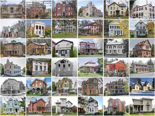
Founding:  1799 Parent county:  Onondaga Namesake:  The Cayuga people Seat:  Aurora (1799–1805); Auburn (1805–) Land area:  692 square miles Population (2020):  76,248 Population (historic):  15,871 (1800); 50,338 (1840); 59,550 (1870); 66,234 (1900); 64,751 (1930) Periods of population growth:  pre-1800–1910; 1930–1990 Subdivisions:  One city; nine villages; one CDP; 23 towns National Register listings:   71 Pre-1940 residences (estimated):  14,265 (38.5%) Pre-1940 housing survival rate:  78.6% Pre-1860 housing survival rate (1940):  33.6% Farm housing in disrepair (1950):  8% Nonfarm housing in disrepair (1950):  4.7% Average farmhouse value (1930):  $1,802 Average outbuilding value (1930):  $1,874 Average farmhouse size (1940):  8 rooms Number of farms (1920):  4,297 Average farm size (1920):  72.5 acres _________________________________________________________________________________   Auburn   Namesake:  The fictional town of Auburn in Oliver Goldsmith's poem  The Deserted Vil

Philadelphia County, Pennsylvania

Image
Founding:  1682 Parent county:  Unorganized territory Namesake:  The city of Philadelphia Seat:  Philadelphia (1682–) Land area:  134 square miles Population (2020):  1,603,797 Population (historic):  54,391 (1790); 258,037 (1840); 674,022 (1870); 1,293,697 (1900); 1,950,961 (1930) Periods of population growth:  pre-1790–1920; 1940s National Register listings:   601 Pre-1940 residences (estimated):  285,003 (41.2%) Pre-1940 housing survival rate:  51.8% Pre-1860 housing survival rate (1940):  16.9% Housing in disrepair (1950):  4.2% Average farmhouse value (1930):  $3,504 Average outbuilding value (1930):  $19,666 Number of farms (1920):  423 Average farm size (1920):  33.5 acres _________________________________________________________________________________   Philadelphia   Namesake:  A Greek neologism meaning "brotherly love" Founding:  1682 (platting); 1701 (incorporation); 1775 (post office) _______________________________________________________________________________

Bucks County, Pennsylvania

Image
Founding:  1682 Parent county:  Unorganized territory Namesake:  Buckinghamshire, England Seat:  Bristol (1705–1726); Newtown (1726–1813); Doylestown (1813–) Land area:  604 square miles Population (2020):  646,538 Population (historic):  25,216 (1790); 48,107 (1840); 64,336 (1870); 71,190 (1900); 96,727 (1930) Periods of population growth:  pre-1790–1830; 1840–1860; 1920–2000 Subdivisions:  24 boroughs; 15 CDPs; 31 townships National Register listings:   168 Pre-1940 residences (estimated):  26,960 (10.7%) Pre-1940 housing survival rate:  85.1% Pre-1860 housing survival rate (1940):  49.8% Farm housing in disrepair (1950):  7.3% Nonfarm housing in disrepair (1950):  3.8% Average farmhouse value (1930):  $3,232 Average outbuilding value (1930):  $2,898 Average farmhouse size (1940):  6.9 rooms Number of farms (1920):  5,714 Average farm size (1920):  48 acres _________________________________________________________________________________   Doylestown   Namesake:  William Doyle, propr

Clearwater County, Minnesota

Image
Founding:  1902 Parent county:  Beltrami Namesake:  The Clearwater River or Clearwater Lake Seat:  Bagley (1902–) Land area:  999 square miles Population (2020):  8,524 Population (historic):  6,870 (1910); 8,569 (1920); 9,546 (1930) Periods of population growth:  pre-1910–1940 Subdivisions:  Five cities; five CDPs; 23 townships National Register listings:   Five Pre-1940 residences (estimated):  733 (15.3%) Pre-1940 housing survival rate:  29.1% Farm housing in disrepair (1950):  15.6% Nonfarm housing in disrepair (1950):  16.3% Average farmhouse value (1930):  $850 Average outbuilding value (1930):  $762 Average farmhouse size (1940):  3.9 rooms Number of farms (1920):  1,253 Average farm size (1920):  52.4 acres Sources of settlement:  Norway, Sweden, Minnesota, and Wisconsin _________________________________________________________________________________   Bagley   Namesake:  Sumner Bagley, Minnesota lumberman Founding:  1894 (platting); 1898 (post office); 1899 (incorporation) Po

Jackson County, Wisconsin

Image
Founding:  1853 Parent county:  La Crosse Namesake:  Andrew Jackson, U.S. president Seat:  Black River Falls (1853–) Land area:  988 square miles Population (2020):  21,145 Population (historic):  4,170 (1860); 13,285 (1880); 17,466 (1900); 16,468 (1930) Periods of population growth:  pre-1860–1900; 1910s; 1930s; 1960–1980; 1990–2020 Subdivisions:  One city; five villages; two CDPs; 21 towns National Register listings:   Six Pre-1940 residences (estimated):  2,002 (20.2%) Pre-1940 housing survival rate:  55.1% Pre-1860 housing survival rate (1940):  4.3% Farm housing in disrepair (1950):  12.5% Nonfarm housing in disrepair (1950):  15.7% Average farmhouse value (1930):  $1,446 Average outbuilding value (1930):  $1,777 Average farmhouse size (1940):  6.3 rooms Number of farms (1920):  2,577 Average farm size (1920):  73.9 acres Sources of settlement:  Norway, Sweden, Germany, and New York _________________________________________________________________________________   Black River Fal

Lebanon County, Pennsylvania

Image
Founding:  1813 Parent counties:  Dauphin and Lancaster Namesake:  The city of Lebanon Seat:  Lebanon (1813–) Land area:  362 square miles Population (2020):  143,257 Population (historic):  16,988 (1820); 31,831 (1860); 38,476 (1880); 53,827 (1900); 67,103 (1930) Periods of population growth:  pre-1820–2020 Subdivisions:  One city; seven boroughs; 14 CDPs; 18 townships National Register listings:   31 Pre-1940 residences (estimated):  14,004 (24.3%) Pre-1940 housing survival rate:  75.2% Pre-1860 housing survival rate (1940):  43.7% Farm housing in disrepair (1950):  7.5% Nonfarm housing in disrepair (1950):  3.4% Average farmhouse value (1930):  $1,823 Average outbuilding value (1930):  $1,968 Average farmhouse size (1940):  7.3 rooms Number of farms (1920):  2,372 Average farm size (1920):  60.1 acres _________________________________________________________________________________   Lebanon   Namesake:  The country of Lebanon Founding:  1753 (platting as Steitztown ); 1792 (post of

Jackson County, Tennessee

Image
Founding:  1801 Parent counties:  Smith Namesake:  Andrew Jackson, U.S. president Seat:  Gainesboro (1820–) Land area:  308 square miles Population (2020):  11,617 Population (historic):  5,401 (1810); 12,872 (1840); 12,583 (1870); 15,039 (1900); 13,589 (1930) Periods of population growth:  pre-1810–1850; 1860s; 1870–1900; 1930s; 1970s; 1990–2010 Subdivisions:  One town; one CDP National Register listings:   Six Pre-1940 residences (estimated):  506 (8.6%) Pre-1940 housing survival rate:  13.9% Pre-1860 housing survival rate (1940):  5.3% Farm housing in disrepair (1950):  35.6% Nonfarm housing in disrepair (1950):  30.9% Average farmhouse value (1930):  $407 Average outbuilding value (1930):  $240 Average farmhouse size (1940):  3.8 rooms Number of farms (1920):  2,403 Average farm size (1920):  38.3 acres _________________________________________________________________________________   Gainesboro   Namesake:  Edmund Gaines, U.S. army officer Founding:  1817 (platting); 1905 (incorp