Carroll County, Illinois
Founding: 1839
Parent county: Jo Daviess
Namesake: Charles Carroll, Maryland politician
Seat: Savanna (1839–1843); Mount Carroll (1843–)
Seat: Savanna (1839–1843); Mount Carroll (1843–)
Land area: 445 square miles
Population (2020): 15,702
Population (historic): 1,023 (1840); 11,733 (1860); 16,976 (1880); 18,963 (1900); 18,433 (1930)
Periods of population growth: pre-1840–1900; 1910s; 1940–1960; 2010s
Subdivisions: Three cities; four villages; 12 townships
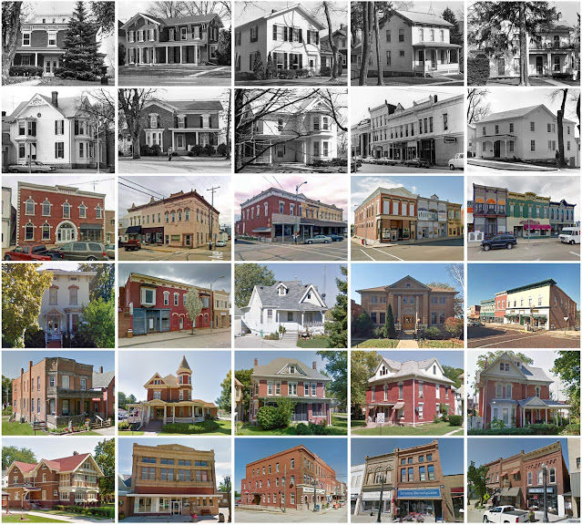
Pre-1940 residences (estimated): 3,161 (37.4%)
Pre-1940 housing survival rate: 61.9%
Pre-1860 housing survival rate (1940): 10.8%
Pre-1940 housing survival rate: 61.9%
Pre-1860 housing survival rate (1940): 10.8%
Farm housing in disrepair (1950): 3.4%
Nonfarm housing in disrepair (1950): 5.3%
Average farmhouse value (1930): $2,258Average outbuilding value (1930): $3,008
Average farmhouse size (1940): 7.3 rooms
Number of farms (1920): 1,769
Average farm size (1920): 127.1 acres
Sources of settlement: Pennsylvania, Germany, New York, Maryland, and Ireland
_________________________________________________________________________________
View and filter the data. Or see a map.
_________________________________________________________________________________

Number of farms (1920): 1,769
Average farm size (1920): 127.1 acres
Sources of settlement: Pennsylvania, Germany, New York, Maryland, and Ireland
_________________________________________________________________________________
Savanna (ex-seat)
Namesake: Prairies near the city site
Founding: 1828 (platting); 1835 (post office); 1874 (incorporation)
Population (2020): 2,783
Population (historic): 658 (1850); 971 (1870); 3,097 (1890); 3,691 (1910); 5,086 (1930)
Periods of population growth: pre-1850–1920; 1940s
Pre-1940 residences (estimated): 833 (49.4%)
Pre-1940 residences (estimated): 833 (49.4%)
_________________________________________________________________________________
Mount Carroll
Namesake: Carroll County
Founding: 1841 (platting); 1845 (post office); 1867 (incorporation)
Population (2020): 1,717
Population (historic): 462 (1850); 1,756 (1870); 1,836 (1890); 1,759 (1910); 1,775 (1930)
Periods of population growth: 1841–1900; 1910s; 1930–1970; 1990s
Pre-1940 residences (estimated): 462 (55.6%)
_________________________________________________________________________________
Pre-1940 residences (estimated): 462 (55.6%)
_________________________________________________________________________________
View and filter the data. Or see a map.
_________________________________________________________________________________


Comments
Post a Comment