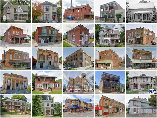
Jackson County, Illinois
Founding: 1816
Parent counties: Johnson and Randolph
Namesake: Andrew Jackson, U.S. president
Seat: Brownsville (1816–1843); Murphysboro (1843–)
Seat: Brownsville (1816–1843); Murphysboro (1843–)
Land area: 584 square miles
Population (2020): 52,974
Population (historic): 1,542 (1820); 5,862 (1850); 19,634 (1870); 33,871 (1900); 35,680 (1930)
Periods of population growth: pre-1820–1920; 1930–1980; 2000s
Subdivisions: Four cities; seven villages; one CDP; 16 townships
Pre-1940 residences (estimated): 3,711 (12.8%)
Pre-1940 housing survival rate: 33.6%
Pre-1860 housing survival rate (1940): 5.7%
Pre-1940 housing survival rate: 33.6%
Pre-1860 housing survival rate (1940): 5.7%
Farm housing in disrepair (1950): 16%
Nonfarm housing in disrepair (1950): 9.4%
Average farmhouse value (1930): $1,050Average outbuilding value (1930): $739
Average farmhouse size (1940): 5.1 rooms
Number of farms (1920): 2,426
Average farm size (1920): 91 acres
Sources of settlement: Tennessee, Louisiana, Kentucky, Missouri, Pennsylvania, and Germany
_________________________________________________________________________________
View and filter the data. Or see a map.
_________________________________________________________________________________

Number of farms (1920): 2,426
Average farm size (1920): 91 acres
Sources of settlement: Tennessee, Louisiana, Kentucky, Missouri, Pennsylvania, and Germany
_________________________________________________________________________________
Murphysboro
Namesake: William Murphy, county commissioner
Founding: 1843 (platting); 1843 (post office); 1867 (incorporation)
Population (2020): 7,093
Population (historic): 2,196 (1880); 6,463 (1900); 8,182 (1930)
Periods of population growth: pre-1880–1920; 1930–1950; 1960s
Pre-1940 residences (estimated): 1,218 (29.7%)
_________________________________________________________________________________
Pre-1940 residences (estimated): 1,218 (29.7%)
_________________________________________________________________________________
View and filter the data. Or see a map.
_________________________________________________________________________________


Comments
Post a Comment