Posts

Showing posts from August, 2020

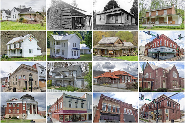
DeKalb County, Tennessee

Image
Founding:  1838 Parent counties:  Cannon, Warren, and White Namesake:  Johann de Kalb, Continental Army general Seat:  Smithville (1838–) Land area:  304 square miles Population (2020):  20,080 Population (historic):  5,868 (1840); 10,573 (1860); 14,813 (1880); 16,460 (1900); 14,213 (1930) Periods of population growth:  pre-1840–1900; 1930s; 1960–2020 Subdivisions:  One city; three towns National Register listings:   Six Pre-1940 residences (estimated):  710 (7.4%) Pre-1940 housing survival rate:  17% Pre-1860 housing survival rate (1940):  7% Farm housing in disrepair (1950):  30.2% Nonfarm housing in disrepair (1950):  21.7% Average farmhouse value (1930):  $448 Average outbuilding value (1930):  $235 Average farmhouse size (1940):  4 rooms Number of farms (1920):  2,792 Average farm size (1920):  40.4 acres _________________________________________________________________________________ Smithville Namesake:  Samuel Smith, Tennessee politician Fo

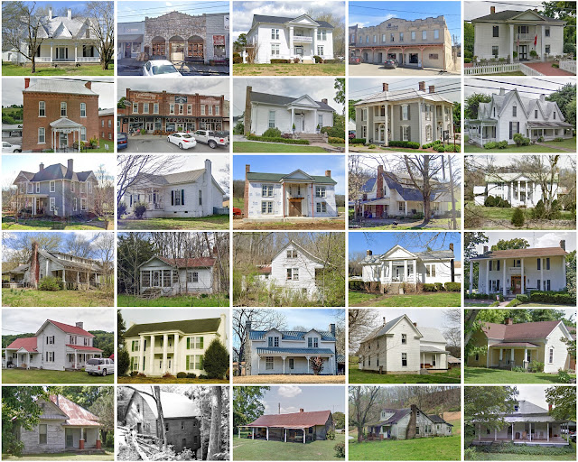
Macon County, Tennessee

Image
Founding:  1842 Parent counties:  Smith and Sumner Namesake:  Nathaniel Macon, North Carolina politician Seat:  Lafayette (1842–) Land area:  307 square miles Population (2020):  25,216 Population (historic):  6,948 (1850); 6,633 (1870); 10,878 (1890); 14,559 (1910); 13,872 (1930) Periods of population growth:  pre-1850–1860; 1870–1920; 1930s; 1960–2020 Subdivisions:  Two cities National Register listings:   Eight Pre-1940 residences (estimated):  616 (6%) Pre-1940 housing survival rate:  17.2% Pre-1860 housing survival rate (1940):  5.5% Farm housing in disrepair (1950):  25.4% Nonfarm housing in disrepair (1950):  26.1% Average farmhouse value (1930):  $440 Average outbuilding value (1930):  $243 Average farmhouse size (1940):  4.3 rooms Number of farms (1920):  2,743 Average farm size (1920):  35.6 acres _________________________________________________________________________________ Lafayette Namesake:  The Marquis de Lafayette, Continental Army

St. Clair County, Missouri

Image
Founding:  1841 (declared in 1833) Parent counties:  Lafayette and unorganized territory Namesake:  Arthur St. Clair, governor of the Northwest Territory Seat:  Osceola (1841–) Land area:  670 square miles Population ( 2020 ):  9,284 Population (historic):  3,556 (1850); 6,742 (1870); 16,747 (1890); 16,412 (1910); 13,289 (1930) Periods of population growth:  pre-1850–1860; 1870–1900; 1970s; 1990–2010 Subdivisions:  Three cities; four villages; 16 townships National Register listings:   Three Pre-1940 residences (estimated):  1,129 (20%) Pre-1940 housing survival rate:  27% Pre-1860 housing survival rate (1940):  2.5% Farm housing in disrepair (1950):  14.6% Nonfarm housing in disrepair (1950):  8.1% Average farmhouse value (1930):  $932 Average outbuilding value (1930):  $699 Average farmhouse size (1940):  4.5 rooms Number of farms (1920):  2,649 Average farm size (1920):  91.7 acres Sources of settlement:  Illinois, Virginia, Ohio, Indiana, Kentucky, and P

Unicoi County, Tennessee

Image
Founding:  1875 Parent counties:  Carter and Washington Namesake:  A Cherokee word referencing the area's fogs Seat:  Erwin (1875–) Land area:  186 square miles Population (2020):  17,928 Population (historic):  3,645 (1880); 5,851 (1900); 12,678 (1930) Periods of population growth:  pre-1880–1950; 1960–2010 Subdivisions:  Two towns; one CDP National Register listings:   Four Pre-1940 residences (estimated):  1,231 (13.8%) Pre-1940 housing survival rate:  43.3% Farm housing in disrepair (1950):  19.8% Nonfarm housing in disrepair (1950):  11.2% Average farmhouse value (1930):  $595 Average outbuilding value (1930):  $251 Average farmhouse size (1940):  4.3 rooms Number of farms (1920):  811 Average farm size (1920):  26.9 acres _________________________________________________________________________________ Erwin Namesake:  David Ervin, owner of the city site Founding:  1879 (post office); 1903 (incorporation) Population (2020):  6,083 Popul

Moore County, Tennessee

Image
Founding:  1872 Parent counties:  Bedford, Franklin, and Lincoln Namesake:  William Moore, Tennessee politician Seat:  Lynchburg (1873–) Land area:  129 square miles Population (2020):  6,461 Population (historic):  6,233 (1880); 5,706 (1900); 4,037 (1930) Periods of population growth:  pre-1880; 1930s; 1960–2020 Subdivisions:  One city National Register listings:   Six Pre-1940 residences (estimated):  260 (8.6%) Pre-1940 housing survival rate:  33.4% Farm housing in disrepair (1950):  28.9% Nonfarm housing in disrepair (1950):  33.2% Average farmhouse value (1930):  $382 Average outbuilding value (1930):  $195 Average farmhouse size (1940):  4.5 rooms Number of farms (1920):  846 Average farm size (1920):  52.9 acres _________________________________________________________________________________ Lynchburg Namesake:  Unknown—perhaps a traditional name Founding:  1820 (post office); 1841 (incorporation) Population (1980):  668 Population (histo

Fentress County, Tennessee

Image
Founding:  1823 Parent counties:  Campbell, Morgan, and Overton Namesake:  James Fentress, Tennessee politician Seat:  Jamestown (1823–) Land area:  499 square miles Population (2020):  18,489 Population (historic):  2,748 (1830); 4,454 (1850); 4,717 (1870); 6,106 (1900); 11,036 (1930) Periods of population growth:  pre-1830–1860; 1870s; 1890–1950; 1970s; 1990–2020 Subdivisions:  Two cities; two CDPs National Register listings:   12 Pre-1940 residences (estimated):  315 (3.5%) Pre-1940 housing survival rate:  14.7% Pre-1860 housing survival rate (1940):  3.8% Farm housing in disrepair (1950):  26.5% Nonfarm housing in disrepair (1950):  33.3% Average farmhouse value (1930):  $292 Average outbuilding value (1930):  $154 Average farmhouse size (1940):  4 rooms Number of farms (1920):  1,214 Average farm size (1920):  30.9 acres _________________________________________________________________________________ Jamestown Namesake:  James Fentress, Tennesse

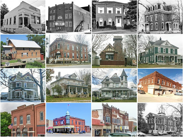
Howard County, Iowa

Image
Founding:  1855 (declared in 1851) Parent county:  Unorganized territory Namesake:  Tilghman Howard, Indiana politician Seat:  Vernon Springs (1856–1858, 1865–1867); Pike's Peak (1858–1865); Cresco (1867–) Land area:  473 square miles Population (2020):  9,469 Population (historic):  3,168 (1860); 10,837 (1880); 14,512 (1900); 13,082 (1930) Periods of population growth:  pre-1860–1900; 1910s; 1930s; 1990s Subdivisions:  Six cities; 12 townships National Register listings:   Eight Pre-1940 residences (estimated):  1,906 (43.6%) Pre-1940 housing survival rate:  55% Pre-1860 housing survival rate (1940):  5.9% Farm housing in disrepair (1950):  6.9% Nonfarm housing in disrepair (1950):  3.1% Average farmhouse value (1930):  $1,951 Average outbuilding value (1930):  $2,654 Average farmhouse size (1940):  6.8 rooms Number of farms (1920):  1,708 Average farm size (1920):  136.1 acres Sources of settlement:  New York, Wisconsin, Ireland, Germany, Czechoslovak

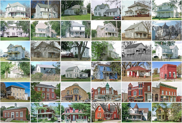
Adams County, Iowa

Image
Founding:  1853 (declared in 1851) Parent county:  Pottawattamie Namesake:  John Adams, U.S. president Seat:   Quincy (1853–1872); Corning (1872–) Land area:  423 square miles Population (2020):  3,704 Population (historic):  1,533 (1860); 11,888 (1880); 13,601 (1900); 10,437 (1930) Periods of population growth:  pre-1860–1900 Subdivisions:  Four cities; 12 townships National Register listings:   Five Pre-1940 residences (estimated):  924 (46%) Pre-1940 housing survival rate:  34.1% Farm housing in disrepair (1950):  3.9% Nonfarm housing in disrepair (1950):  7.1% Average farmhouse value (1930):  $1,894 Average outbuilding value (1930):  $2,022 Average farmhouse size (1940):  6.1 rooms Number of farms (1920):  1,629 Average farm size (1920):  148.6 acres Sources of settlement:  Illinois, Ohio, Indiana, and Pennsylvania _________________________________________________________________________________ Corning Namesake:  Unknown—perhaps Corning, New York

Delaware County, Iowa

Image
Founding:  1844 (declared in 1837) Parent county:  Dubuque Namesake:  Uncertain—perhaps the Delaware (Lenape) people Seat:  Delhi (1842–1880); Manchester (1880–) Land area:  578 square miles Population (2020):  17,488 Population (historic):  1,759 (1850); 17,432 (1870); 17,349 (1890); 17,888 (1910); 18,122 (1930) Periods of population growth:  pre-1850–1880; 1890s; 1910s; 1930s; 1950–1980; 1990s Subdivisions:  12 cities; 16 townships National Register listings:   15 Pre-1940 residences (estimated):  2,545 (31.4%) Pre-1940 housing survival rate:  54.7% Pre-1860 housing survival rate (1940):  6.7% Farm housing in disrepair (1950):  5.8% Nonfarm housing in disrepair (1950):  9.6% Average farmhouse value (1930):  $2,372 Average outbuilding value (1930):  $3,515 Average farmhouse size (1940):  7 rooms Number of farms (1920):  2,284 Average farm size (1920):  122 acres Sources of settlement:  New York, Germany, Pennsylvania, Ohio, Ireland, Illinois, and England _

Kenosha County, Wisconsin

Image
Founding:  1850 Parent county:  Racine Namesake:  The city of Kenosha Seat:  Kenosha (1850–) Land area:  272 square miles Population (2020):  169,151 Population (historic):  10,734 (1850); 13,147 (1870); 15,581 (1890); 32,929 (1910); 63,277 (1930) Periods of population growth:  pre-1850–1860; 1870–2020 Subdivisions:  One city; six villages; four CDPs; five towns National Register listings:   31 Pre-1940 residences (estimated):  12,897 (18.4%) Pre-1940 housing survival rate:  67% Pre-1860 housing survival rate (1940):  18.4% Farm housing in disrepair (1950):  6% Nonfarm housing in disrepair (1950):  2% Average farmhouse value (1930):  $2,869 Average outbuilding value (1930):  $3,146 Average farmhouse size (1940):  6.9 rooms Number of farms (1920):  1,383 Average farm size (1920):  81.2 acres Sources of settlement:  New York, Germany, Ireland, Illinois, and England _________________________________________________________________________________ Kenosha

Jefferson County, Iowa

Image
Founding:  1839 Parent counties:  Henry and unorganized territory Namesake:  Thomas Jefferson, U.S. president Seat:  Fairfield (1839–) Land area:  436 square miles Population (2020):  15,663 Population (historic):  9,904 (1850); 17,839 (1870); 15,184 (1890); 15,951 (1910); 16,241 (1930) Periods of population growth:  pre-1850–1870; 1890s; 1910s; 1950s; 1970s; 2000s Subdivisions:  Eight cities; 12 townships National Register listings:   29 Pre-1940 residences (estimated):  2,249 (29.5%) Pre-1940 housing survival rate:  52.9% Pre-1860 housing survival rate (1940):  3.4% Farm housing in disrepair (1950):  12.4% Nonfarm housing in disrepair (1950):  5.8% Average farmhouse value (1930):  $2,035 Average outbuilding value (1930):  $1,842 Average farmhouse size (1940):  6.5 rooms Number of farms (1920):  1,960 Average farm size (1920):  98.1 acres Sources of settlement:  Pennsylvania, Ohio, Indiana, Kentucky, Illinois, Wisconsin, Sweden, and Germany _______________

Essex County, New York

Image
Founding:  1799 Parent county:  Clinton Namesake:  Essex, England Seat:  Essex (1799–1807); Elizabethtown (1807–) Land area:  1,794 square miles Population (2020):  37,381 Population (historic):  9,477 (1810); 23,634 (1840); 29,042 (1870); 30,707 (1900); 33,959 (1930) Periods of population growth:  pre-1810–1850; 1860–1880; 1900s; 1920–1960; 1970–2010 Subdivisions:  Two villages; 11 CDPs; 18 towns National Register listings:   123 Pre-1940 residences (estimated):  8,646 (33%) Pre-1940 housing survival rate:  84.8% Pre-1860 housing survival rate (1940):  20.6% Farm housing in disrepair (1950):  11.2% Nonfarm housing in disrepair (1950):  8.2% Average farmhouse value (1930):  $2,183 Average outbuilding value (1930):  $1,571 Average farmhouse size (1940):  7.7 rooms Number of farms (1920):  1,978 Average farm size (1920):  57.8 acres _________________________________________________________________________________ Elizabethtown Namesake:  Elizabeth Gilli

Cedar County, Iowa

Image
Founding:  1837 Parent county:  Dubuque Namesake:  The Cedar River Seat:  Rochester (1837–1841); Tipton (1841–) Land area:  579 square miles Population (2020):  18,505 Population (historic):  3,941 (1850); 19,731 (1870); 18,253 (1890); 17,765 (1910); 16,760 (1930) Periods of population growth:  pre-1850–1870; 1890s; 1930–1960; 1970s; 1990–2020 Subdivisions:  Nine cities; one CDP; 17 townships National Register listings:   18 Pre-1940 residences (estimated):  2,954 (36%) Pre-1940 housing survival rate:  63.7% Pre-1860 housing survival rate (1940):  8.4% Farm housing in disrepair (1950):  3.2% Nonfarm housing in disrepair (1950):  5.4% Average farmhouse value (1930):  $2,760 Average outbuilding value (1930):  $3,690 Average farmhouse size (1940):  7.4 rooms Number of farms (1920):  2,212 Average farm size (1920):  139 acres Sources of settlement:  Ohio, Pennsylvania, Germany, New York, and Ireland ______________________________________________________________