Somerset County, Maryland


Founding: 1666
Parent county: Unorganized territory
Namesake: Somerset, England
Seat: Ilchester (1675–1683); Unity (1683–1694); Dividing Creek (1694–1747); Princess Anne (1747–)
Land area: 320 square miles
Population (2020): 24,620
Population (historic): 15,310 (1790); 19,508 (1840); 18,190 (1870); 25,923 (1900); 23,382 (1930)
Periods of population growth: pre-1790–1800; 1810s; 1840–1860; 1870–1890; 1980s
Subdivisions: One city; one town; nine CDPs
National Register listings: 74
Pre-1940 residences (estimated): 2,158 (18.9%)
Pre-1940 housing survival rate: 35.7%
Pre-1860 housing survival rate (1940): 12.2%
Farm housing in disrepair (1950): 13.9%
Nonfarm housing in disrepair (1950): 18.2%
Average farmhouse value (1930): $1,418
Average outbuilding value (1930): $786
Average farmhouse size (1940): 5.7 rooms
Number of farms (1920): 1,820
Average farm size (1920): 38.9 acres
_________________________________________________________________________________
 
Princess Anne
 
Namesake: Anne of Orange, British princess
Founding: 1733 (founding); 1792 (post office); 1867 (incorporation)
Population (2020): 3,446
Population (historic): 805 (1870); 865 (1890); 1,006 (1910); 975 (1930)
Periods of population growth: pre-1870; 1880s; 1900s; 1940s; 1970–2010
Pre-1940 residences (estimated): 204 (11.9%)
_________________________________________________________________________________


View and filter the data. Or see a larger map.
_________________________________________________________________________________
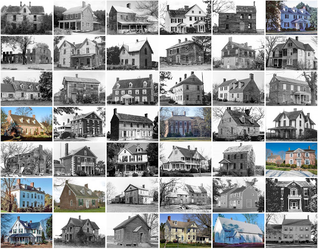
Outstanding Buildings

  1. *Elisha Riggin House (c. 1836). 26800 Cash Corner Road.
  2. *William Costen House (1829). Cokesbury Road, northwest of Wallace Taylor Road. Federal. Razed.
  3. *Rehobeth Episcopal Church Ruins (1785–1788). Coventry Parish Road, east of Old Rehobeth Road.
  4. *Tudor Hall / Francis Waters House (c. 1790). 28131 Fairmount Road. Georgian.
  5. *Hayward's Lott / Thomas Hayward House (c. 1730). 7790 Hayward Road. Georgian.
  6. *Sudler's Conclusion (c. 1720/1840). 8720 Hood Road.
  7. *Arlington / Ephraim Wilson Farm (c. 1755). 9001 James Ring Road. Georgian.
  8. *Make Peace / Roach House (c. 1725). 27012 Johnson Creek Road.
  9. *Elmwood / Arnold Jones House (c. 1820). 10067 Locust Point Road. Federal.
  10. *Almodington / John Elzey House (c. 1750). Locust Point Road, south of Oriole Road. Georgian.
  11. *Beckford / John Dennis House (c. 1803). 11700 Mansion Street. Georgian.
  12. *Francis Barnes Farm (c. 1870). Mennonite Church Road, south of Greenhill Lane. Gothic Revival. Razed.
  13. *Waterloo / Henry Waggaman House (c. 1755). 28822 Mount Vernon Road. Georgian.
  14. *Woolford–Adams Farm (c. 1830/1900). 11179 Old Princess Anne Road. Eastlake.
  15. *Kingston Hall / Thomas King Farm (1755). 7526 Old Westover–Marion Road. Georgian.
  16. *Beverly / Nehemiah King House (c. 1790). 30590 Perry Road. Georgian.
  17. *Jarvis Ballard House (c. 1750). Perryhawkin Road, east of Post Office Road.
  18. *Watkins Point Farm / Horsey House (c. 1785/1850). 27737 Phoenix Church Road. Greek Revival.
  19. *Clifton / James Elzey House (c. 1805). 28236 Revell's Neck Road. Federal.
  20. *Caldicott / Littleton Dennis House (c. 1790). 31841 Vessey Orchard Road. Georgian.


Comments